You may have stood on a beach and watched the water pull back, exposing a wide stretch of sand, then return hours later to cover your footprints. Or you might notice that the timing of that high water shifts a little later each day, as if the sea were on its own schedule. Tides are among the most visible rhythms of our planet, an ancient clock that sailors and shorebirds have trusted for millennia, and understanding them connects you to the motion of the whole Earth-moon-sun system.
Tides are not magic, and they are not caused by a single force. Instead, they are the result of a graceful tug-of-war between gravity and motion, shaped by the shape of oceans, the tilt of the Earth, and even weather. By the end of this piece you will be able to explain why two bulges of water form, why some places have enormous tides while others barely notice, and how people predict and use tides in everyday life.
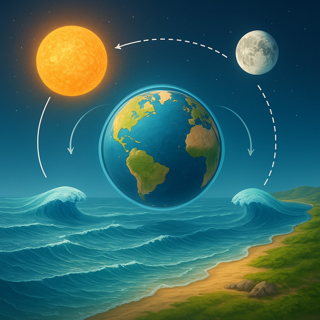
How gravity stretches the oceans and why there are two bulges
The primary actor in the tidal story is gravity, and the primary gravitational partner is the Moon. Gravity pulls objects toward one another, and the Moon pulls on every bit of the Earth, including its oceans. But the Moon is much closer to the side of the Earth that faces it than to the far side, so the pull is slightly stronger on the near side. That difference in pull across the diameter of the Earth is called a tidal force, and it stretches the planet-long line between the near and far sides.
This stretching creates two bulges of water. On the side facing the Moon, water is pulled toward the Moon and forms a bulge. On the opposite side, water bulges too, but for a different reason - not because the Moon pulls harder there, but because the Earth and Moon orbit a common center of mass. This orbit produces an outward inertial effect, often described with the helpful concept of centrifugal force, which tends to fling water away from the center of rotation. The combination of the Moon's varying pull and that outward tendency produces two high tides on opposite sides of the globe at the same time.
Rotating Earth and the rhythm of two daily tides
The Earth spins under these tidal bulges, so any given coastal location moves into and out of the bulges as the planet rotates. For many places, this means roughly two high tides and two low tides every lunar day. A lunar day is about 24 hours and 50 minutes because while the Earth rotates once relative to the Sun in 24 hours, it must rotate a bit longer for the Moon to return to the same overhead position. That extra 50 minutes is why the time of high tide shifts later by about 50 minutes each day.
It helps to picture the bulges as slowly chasing the Moon around the Earth. As your shoreline passes beneath a bulge you get a high tide, and when you pass between bulges you get low tide. The bulges do not follow the Moon perfectly due to friction with the seafloor and the continents crowding the water, so local timing and amplitude are shaped by geographic details too.
When the Sun steps in: spring tides and neap tides
The Sun is far more massive than the Moon, and it also exerts a tidal force on the Earth's oceans. Because the Sun is so much farther away, its tidal influence is about half that of the Moon. When the Sun and Moon line up, their tidal effects reinforce each other, producing higher high tides and lower low tides called spring tides. This happens at full moon and new moon when the Sun, Earth, and Moon are roughly in a line.
At first and last quarter moons, the Sun and Moon are at roughly right angles relative to the Earth. Their tidal forces partially cancel, producing neap tides - smaller differences between high and low water. Spring and neap tides form a roughly two-week cycle within the larger lunar rhythm, so coastal waters rise and fall in a pattern driven by the dance of both celestial bodies.
Why the same tide pattern looks different along different coasts
If the mechanisms above were the whole story, tides would be identical at every point on Earth, but they are not. The shapes of continents, the depth of the ocean, and the layout of bays and estuaries strongly modify tidal patterns. When water moves into a narrowing bay, it can be forced upward, amplifying tidal range in a way similar to focusing waves into a cone. The Bay of Fundy between Nova Scotia and New Brunswick is the classic example, where funneling and resonance combine to produce some of the largest tides on Earth, exceeding 15 meters.
Resonance works like pushing a child on a swing. If the natural oscillation period of a basin matches the period of the tidal forcing, the water can slosh energetically and amplify the range. Conversely, in enclosed seas or places with shallow shelves, tides may be small because the geometry prevents effective bulge formation. Ocean currents, seabed friction, and the Coriolis effect - the apparent deflection caused by Earth's rotation - further twist the pattern, producing amphidromic systems where nodes experience almost no tide while surrounding areas rotate around with varying phases.
A compact table to compare what changes tidal behavior
| Factor |
How it alters tides |
Typical effect |
| Moon's gravity |
Creates main tidal bulges |
Primary driver of tidal timing and amplitude |
| Sun's gravity |
Adds or subtracts from lunar tides |
Spring-neap cycle (fortnightly changes) |
| Earth rotation |
Moves coasts through bulges |
Two high tides per lunar day in many places |
| Basin shape and coastline |
Funnels or damps tidal flow |
Can greatly amplify or reduce local range |
| Ocean depth and seafloor friction |
Changes wave speed and energy loss |
Shallow shelves slow and amplify tides |
| Resonance |
Matches tidal period to basin oscillation |
Can produce extreme tidal ranges |
| Atmospheric pressure and winds |
Push water toward or away from coasts |
Short-term storm surges or suppressed tides |
Tidal myths and clarifications everyone should know
Let us clear up the most common confusions so you can sound smart at the next picnic. First, tides are not caused by the Earth's rotation alone. The rotation moves you through tidal bulges, but the bulges themselves come from gravitational differences and orbital motion. Second, the Moon does not "pull the ocean toward it and leave the rest behind" in a simplistic way; the tidal effect is a gradient - a subtle difference in pull across the planet. Third, there are usually two high tides per day, but not always. Some coasts experience one high tide, called diurnal tides, and others have mixed semidiurnal patterns depending on local geography.
Another misconception is that high tide occurs exactly when the Moon is overhead. In many places it is close, but the tidal bulge is slowed and shifted by continents and friction, so the timing and height of high tide can lag behind the Moon's position. Also, weather can temporarily override tidal expectations - a strong onshore wind or low atmospheric pressure can raise water levels for hours or days, causing storm surge that is unrelated to the celestial cycle.
How scientists predict tides and why it's practical
Tide prediction is a mature science based on harmonic analysis, where measured sea-level records are decomposed into a set of sinusoidal components each tied to an astronomical frequency. These components include the lunar and solar terms and smaller corrections for the Moon's orbit eccentricity, inclination, and other orbital complexities. By summing these components, scientists and tidal prediction offices produce tide tables that mariners, fishermen, and coastal planners use to know when high and low water will occur.
Tide gauges and satellites like altimeters feed data into models that update charts, while local observations help refine predictions for complex bays. Knowing tides matters for navigation - ships require clearance to enter a harbor - and for safety - surfers and swimmers benefit from understanding the timing. Tidal knowledge enables tidal energy projects that harvest predictable flows, and it is crucial for coastal flood risk assessments as sea levels rise.
Small experiments and observations you can make right now
You can experience the logic of tides without leaving shore. Visit the same spot at a harbor or beach over several days and note the times of high and low water. You will see the high tide time shift later by roughly 50 minutes each day. If you chart the heights you may notice the two-week spring-neap modulation. Another simple demonstration uses a bowl of water to think about bulges: hold a heavy ball near one side and see how the water surface tilts slightly toward the ball, then spin the bowl slowly on a turntable to feel how rotation produces outward slumping of water. These tabletop tricks are not perfect models, but they make the basic forces intuitive.
For a more involved project, compare tide tables for two nearby ports with different coast lines for a week. Note how timing and amplitude vary and try to relate those differences to the shape of the shoreline, the presence of estuaries, or known shoals. Observation plus a little background reading on local bathymetry teaches faster than abstract description alone.
How tides interact with storms, sea-level rise, and human activity
Tides and weather can combine with dangerous results. A storm surge riding on top of a spring high tide creates particularly destructive flooding because the baseline is already elevated. As global mean sea level rises, the same tide heights will arrive higher onshore, increasing the frequency of coastal flooding even without stronger storms. Human activities also change local tidal dynamics: building seawalls, dredging channels, or filling wetlands modifies how water moves in and out of an area, sometimes reducing natural buffering and increasing vulnerability.
On the positive side, understanding tides allows for thoughtful engineering - designing docks and flood defenses that accommodate expected tidal ranges, and planning recreational and commercial activities around predictable windows. Tidal power projects aim to harness the reliable ebb and flow of water to generate electricity, with both tidal barrages and in-stream turbines already operating in several places around the world.
A few takeaways to remember and say aloud
- Tides are caused mainly by differences in gravitational pull from the Moon and, to a lesser extent, the Sun, combined with Earth-Moon orbital motion that produces two bulges.
- The Earth’s rotation carries coastlines through those bulges, giving many places two high tides and two low tides each lunar day.
- Local geography, ocean depth, and resonance can greatly change the timing and size of tides, which is why the Bay of Fundy is so extreme while the Mediterranean sees small tides.
- Spring and neap tides are the result of the Sun and Moon reinforcing or canceling each other’s pull every two weeks.
- Weather, sea-level rise, and human construction all modulate tidal impacts and are important for coastal planning.
Go watch the sea and be curious
Tides are one of the cleanest and most elegant demonstrations of physics at planetary scales. They show how a handful of universal principles - gravity, motion, and resonance - combine with the messy details of coastlines to produce the rhythms you can see and predict. Next time you watch the water pull back and rush forward, you will know you are observing the shape of the Earth, the pull of a distant Moon, and the steady influence of the Sun all acting together. Take a small notebook, time the next high tide, and enjoy the feeling of understanding something both ancient and immediate.