Think of the modern city as a high-stakes game of Tetris played with two-ton metal blocks. Every morning, millions of packages, meals, and grocery orders move through narrow streets, only to hit an immovable wall: the curb. For decades, city planners treated the sidewalk edge like a static slab of concrete, using permanent signs and unchanging rules that ignored the reality of our just-in-time economy. When a delivery driver finds a loading zone occupied by a sedan parked for a morning coffee break, the only remaining option is to double-park. This turns a four-lane boulevard into a chaotic lot of stalled engines and blaring horns.
We are currently witnessing a shift in how we manage urban movement, moving away from archaic painted curbs toward the idea of the curb as a dynamic, temporary resource. By treating the space next to the sidewalk like a hotel room or an airplane flight path, planners are finally acknowledging that the speed of a city depends on how it manages small, precious segments of asphalt. This new framework, known as dynamic curb management, relies on digital reservation systems and real-time connectivity to replace the guessing game of parking with the precision of a digital ledger. It is a quiet revolution that turns a static street grid into a fluid, responsive network that pulses according to the actual needs of the people and businesses moving through it.
The Tyranny of the Static Curb
The fundamental problem with historic city planning is its rigidity, which assumes that the demand for space is constant throughout the day. In the old model, a loading zone might be marked for delivery vehicles between 7:00 AM and 10:00 AM, yet it often sits empty in the afternoon. Worse, it is often hijacked by unauthorized vehicles because parking enforcement officers cannot be everywhere at once. When the infrastructure cannot adapt to the shifting rhythm of the city, the inevitable result is friction. This manifests as delivery vans idling in travel lanes, blocking buses, and creating dangerous bottlenecks for cyclists. This constant search for space is not just a nuisance, but a massive inefficiency that adds hidden costs to every delivery made within a city.
When we view the curb as a physical object rather than a digital asset, we limit the capacity of our streets to handle the modern load. A street is not just a tube for cars, but a marketplace for activity, and that marketplace is currently suffering from a lack of inventory management. If a delivery driver knows exactly where a pre-booked, empty space is located before they turn the corner, the amount of time spent circling the block drops to almost zero. By digitizing the rules of the road, we transform the street from a chaotic, competitive environment into a coordinated, logical system where every inhabitant has a clear, reserved role in the movement of goods.
How Digital Reservations Reclaim the Street
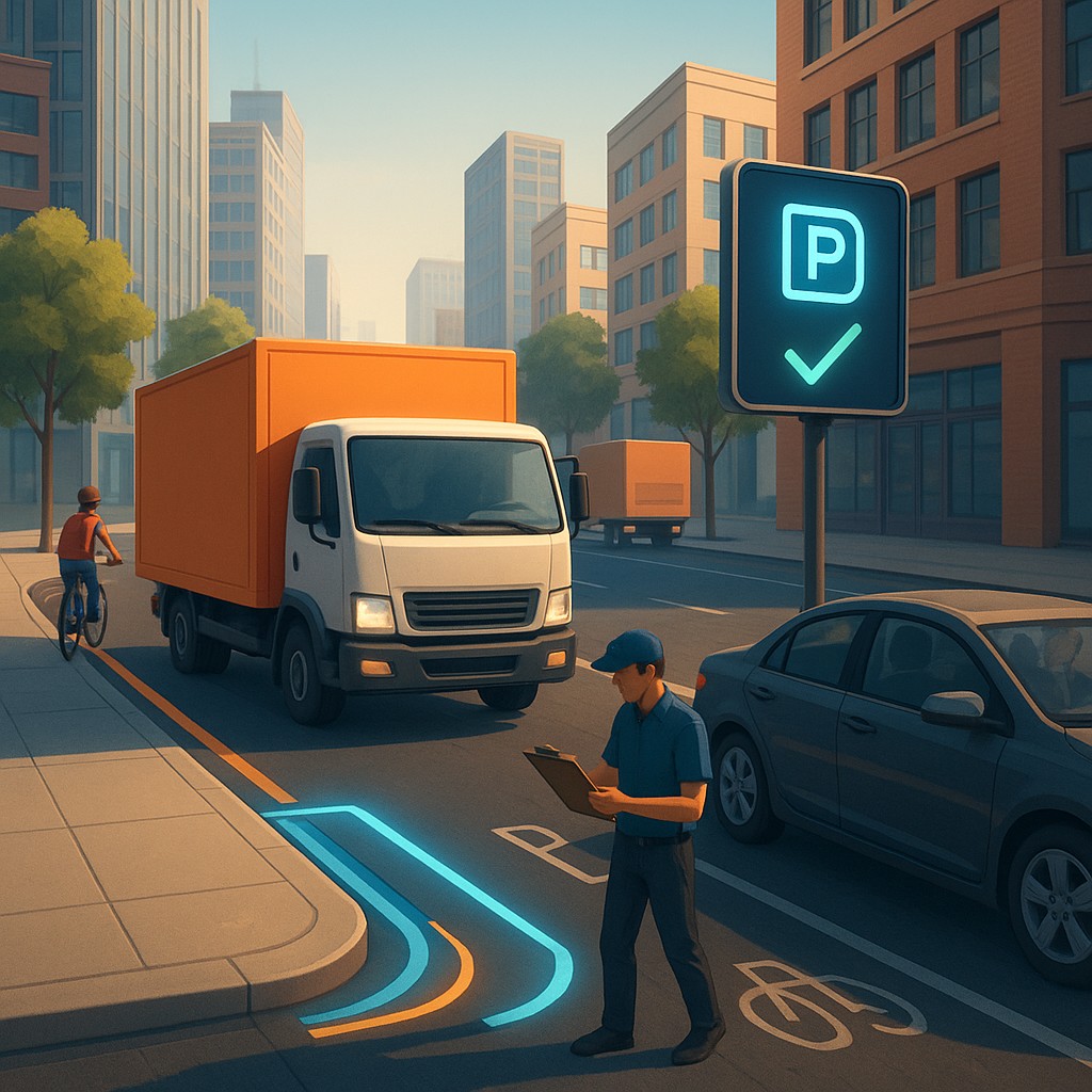
The transformation of the curb begins with converting physical rules into data that navigation software and delivery apps can interpret in real time. Instead of relying on a faded stencil on the pavement, cities now upload their curb data into centralized platforms that talk directly to the dispatch and routing systems used by logistics companies. A delivery driver receives a notification on their dashboard stating that their loading slot at 4th and Main is reserved for 9:15 AM. This ensures that when they pull up, the space is legally and physically guaranteed for their arrival. This creates a virtual landing strip for goods, where the coordination happens in the cloud before the vehicle ever enters the complex weave of city traffic.
To ensure compliance, these smart zones are often equipped with sensors that track vehicle presence, feeding data back to a central dashboard. This allows city authorities to monitor usage patterns. This is not about surveillance for the sake of punishment; it is about observing the pulse of the city to adjust inventory levels. If one zone is consistently overbooked, the city can digitally expand the reservation window or reallocate nearby space to handle the demand. The following table contrasts the old, static approach with the emerging dynamic model:
| Attribute |
Traditional Curb Management |
Dynamic Curb Management |
| Logic |
Static signage and painted lines |
Real-time digital reservations |
| User Experience |
Guesswork and circle-driving |
Precise, pre-booked arrival slots |
| Policy Flexibility |
Rigid, changing only by city worker |
Programmatic, changing by the minute |
| Street Impact |
Frequent double-parking |
Streamlined, predictable delivery |
| Data Visibility |
Low; manual ticketing and patrol |
High; sensor-verified usage stats |
The Mechanics of Just-in-Time Urbanism
At the heart of this shift is the concept of vehicle-to-curb interaction, which allows for high-density reuse of small spaces. Think of it like a dance where the steps are communicated via sensors and digital pathways (APIs) rather than hand signals. When a delivery vehicle approaches, the software uses geolocation to confirm the driver is nearby and verifies their digital permit. It may even trigger a smart sign at the location to blink or change color to indicate that the spot is reserved. This creates a virtuous cycle where limited space is used to its full potential, allowing a single curb segment to serve ten different delivery companies in a window where it might have previously served only three.
This approach also solves the "last-mile" dilemma by reducing the time professional drivers spend looking for parking. By eliminating the variation in arrival and parking times, logistics firms can optimize their routes with much higher certainty. When a driver knows there is guaranteed access to a spot, they are less likely to double-park. This improves traffic flow and enhances the reliability of public transit that shares the road. It replaces the expensive, wasteful practice of cruising for parking with a model of scheduled arrival that treats the city as a shared, high-performance logistics asset.
Navigating the Challenges of Implementation
Transitioning to a dynamic model is not without its hurdles. It requires both technological infrastructure and a fundamental shift in how residents view street access. One significant challenge is interoperability. Cities must ensure that digital reservation platforms are open and accessible to all delivery fleets, from major logistics giants to small, local couriers. If the systems are proprietary or closed off, they could create a fragmented landscape where only the largest fleets can participate, leaving smaller players to fight over the remainders. Furthermore, cities must balance their desire for efficiency with the need for fairness, ensuring that the curb remains a public good even as it becomes a digital utility.
There is also the matter of public perception, as citizens often associate parking with personal property rights rather than shared infrastructure. Transitioning to a model of paid or strictly scheduled loading zones may be met with resistance, as drivers prefer the flexibility of free access over the rigid requirements of a booking system. Addressing these concerns requires clear communication and evidence that the system leads to safer streets and faster, cheaper, and more sustainable deliveries. As the data consistently shows that managed curb space reduces traffic congestion and illegal maneuvers, the public will likely grow to appreciate the order and predictability that digital management provides.
The Future of Connected Streets
The beauty of dynamic curb management is its expandability. The same framework used for delivery vehicles can eventually be applied to rideshare drop-offs, food trucks, and even priority lanes for emergency vehicles. We are moving toward a future where our streets are no longer static, concrete entities that struggle to accommodate modern life, but dynamic, living networks that react to our movements in real time. This is not about adding lanes or widening roads; it is about smarter allocation through the intelligent application of data. It is a shift from the brutish, physical management of space to an elegant, software-driven approach that respects the complexity of the urban environment.
As we look toward the cities of the future, we can imagine a streetscape where the frustration of gridlock is replaced by the orderly synchronization of connected vehicles. We are moving toward a reality where the curb is an asset that contributes to the city's health, safety, and vitality, rather than a point of conflict. By embracing these digital tools, we are not just solving a parking problem; we are reclaiming the time and energy lost to friction, allowing our cities to become the efficient, vibrant powerhouses they were always meant to be. The next time you see a delivery van pull into a perfectly open space on a busy afternoon, remember that it is not a coincidence, but the result of a coordinated and brilliantly managed dance of data.