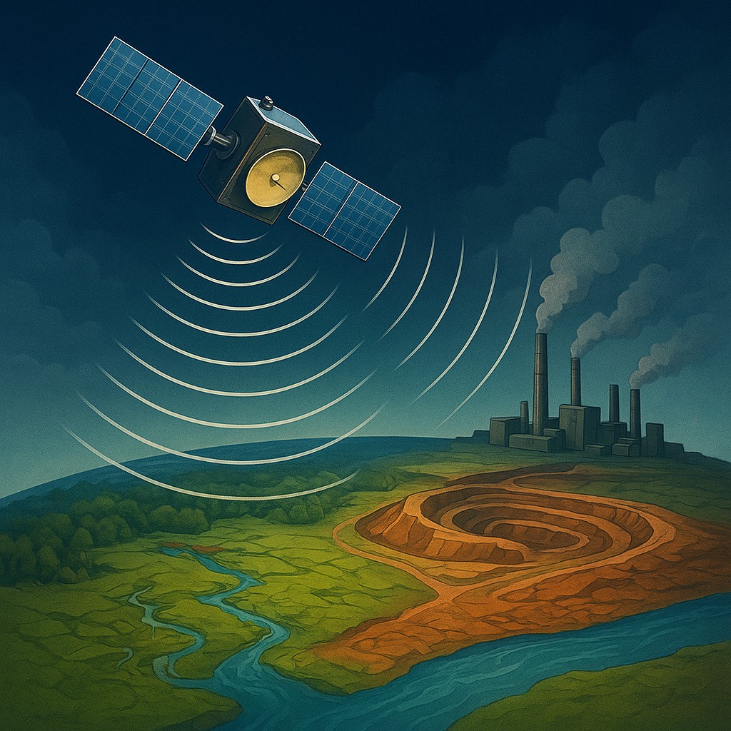
For decades, international law rested on shaky trust and high-stakes games of hide-and-seek. When a nation signed an environmental treaty to protect ancient aquifers or limit underground mining, the global community usually had to take their word for it. The only way to verify these promises was through on-site inspections, but these were easily blocked. Governments could close their borders, redirect inspectors away from sensitive areas, or bank on the fact that a single mine can be as large as a small city. To hide a major environmental violation, a country simply had to lock the gate and keep the cameras away.
That era of "plausible deniability" is now ending. New technology can watch from hundreds of miles above, peering through the dark of night and the thickest monsoon clouds. International courts and regulators are using Synthetic Aperture Radar (SAR) as an orbital private investigator. By measuring the Earth's surface with millimeter precision, SAR allows scientists to detect the subtle rising and falling of the ground. It turns the planet's crust into a digital ledger that records every secret tunnel and illegal water draw, creating an audit trail that exists entirely outside a nation's physical control.
The Physics of Orbital Echoes
To understand how a satellite can spot a three-millimeter shift in the dirt from outer space, we first have to distinguish between standard cameras and radar. Most satellites are essentially giant digital cameras. They need sunlight to see, and they are easily blinded by clouds, smoke, or dust. Synthetic Aperture Radar, however, is an active system. It does not wait for the sun to light up the Earth. Instead, the satellite beams its own microwave pulses down to the surface and listens for the echo as those signals bounce back. Because microwaves have long wavelengths, they pass through clouds and rain as if they were not even there.
The "Synthetic Aperture" part of the name refers to a piece of mathematical cleverness. In physics, the sharpness of a radar image depends on the size of the antenna: the larger the antenna, the clearer the picture. To get high-resolution images of a city from space, you would need an antenna miles long, which would be impossible to launch. To solve this, SAR uses the movement of the satellite itself. As the spacecraft streaks across the sky at thousands of miles per hour, it takes thousands of rapid-fire snapshots of the same spot from different angles. Powerful processors then stitch these signals together, mimicking the effect of a massive, miles-long antenna. This allows a relatively small, manageable spacecraft to see incredible detail.
Reading the Earth's Subtle Breath
The real breakthrough comes from a process called Interferometry, or InSAR. This technique involves taking two SAR images of the exact same location at different times and overlaying them. If the ground has not moved at all between the first and second pass, the radar waves return in the exact same phase, or timing. However, if the ground has risen or sunk even slightly, the distance the microwave travels changes. This causes a shift in the timing of the returning wave. When these two images are compared, they create an "interferogram," a map covered in colorful, psychedelic swirls that represent physical movement.
If you have ever seen a rainbow pattern in an oil slick on a puddle, you have seen the basic principle of interference. On an InSAR map, each cycle of colors represents a specific amount of ground movement. If these colorful rings tighten around a specific area, it shows the ground is sinking, a process called subsidence. By counting these rings, scientists can calculate exactly how many centimeters the Earth has moved over a month or a year. This is more than a science trick; it is a forensic tool. When an aquifer is pumped dry or a mine is hollowed out, the ground above often loses its support and begins to sag. These digital fingerprints cannot be hidden under a tarp or behind a tall fence.
Evidence in the Court of Global Opinion
International environmental treaties, such as those protecting shared water sources or regulating carbon storage, often lack "teeth" because proof is hard to find for legal cases. A farmer complaining that a well has run dry is just a personal story. However, a colorful InSAR map showing a ten-centimeter drop in the water table across a 50-mile radius is hard data. International courts are now using these "deformation patterns" as objective evidence. For example, if a treaty forbids expanding a coal mine near a forest, SAR can detect the subtle settling of the ground as new tunnels are dug deep below, even if the entrance to the mine is miles away.
This technology shifts the burden of proof. In the past, an accuser had to gain physical access to a site to prove a violation. Now, the satellite provides the evidence automatically, and the accused party must explain why the Earth is sagging beneath their feet. It creates a global layer of transparency that works regardless of whether a country allows an inspection. This is vital for monitoring groundwater. Because water is hidden, it is often treated as an invisible, infinite resource. SAR makes the loss of that water visible to everyone, allowing courts to treat "water theft" with the same seriousness as the theft of physical property.
Sorting Human Signals from Natural Noise
One of the biggest challenges in using SAR for legal cases is the "signal-to-noise" problem. The Earth is a living, moving object. Ground can shift because of tectonic plates, natural soil settling, heat expansion during summer, or the weight of heavy snow. If an international court is going to issue a fine based on satellite data, experts must prove that the sinking was caused by human activity, like illegal pumping, rather than natural geology.
This requires advanced data processing and a broad understanding of geology. Analysts look for specific shapes in the sinking ground. Natural geological shifts usually happen over very wide areas and follow the lines of mountain ranges or faults. Human-induced sinking, however, often produces sharp, localized "cones of depression." If a sinking zone perfectly matches the borders of an industrial farm or an unapproved mine, the fingerprint of human activity becomes clear. The following table shows how SAR tells the difference between various types of ground movement.
| Cause of Movement |
Pattern Shape |
Speed of Shift |
Legal Implications |
| Groundwater Pumping |
Circular or oval "cones" over wells. |
Medium (5-20 cm per year). |
Often shows treaty violations or illegal irrigation. |
| Mining Activity |
Lines or small pockets of sagging over tunnels. |
High (up to 50 cm per year). |
Reveals secret expansion of underground work. |
| Tectonic Shift |
Wide, regional tilt over hundreds of miles. |
Low (1-5 cm per year). |
Natural event; no legal violation. |
| Thawing Permafrost |
Patchy, irregular sinking in arctic areas. |
Varies (Seasonal cycles). |
Tracks climate change rather than local illegal acts. |
The Ethics of the Invisible Eye
Like any powerful surveillance tool, SAR raises questions about national rights and privacy. Is it a violation of a country's sovereignty to have its soil measured so precisely without permission? While international law says states control their physical land, the "vertical frontier" of space follows different rules. Most space treaties allow for the peaceful observation of Earth from above, but the jump from "scientific study" to "legal prosecution" is a new and blurry area.
There is also the question of who holds the data. High-quality SAR used to be for military superpowers only. Today, commercial companies and groups like the European Space Agency (ESA) provide much of this data to the public. While this helps small non-profits hold large corporations and governments accountable, it also means sensitive geological info is out in the open. Going forward, international courts will need to create standard "rules of evidence" for satellite data to ensure it is used fairly and that the computer programs used to read it are unbiased.
The Future of Global Verification
We are moving toward a world where the environment is no longer a "black box" that can be exploited in secret. Using SAR in international law marks a major shift in how we manage the planet. It moves us away from a system based on "trust but verify" toward one of constant, objective monitoring. This does more than just catch people after they break the rules; it acts as a powerful deterrent. When a government knows its actions are being recorded in the very dirt for the whole world to see, the pressure to follow the rules increases.
Imagine a future where every environmental treaty comes with "digital guardrails" monitored by satellites. If a protected wetland starts to dry up or a forbidden mine is opened, the system could automatically alert international monitors. This level of transparency could help solve complex global problems, from sharing river systems to protecting carbon credits. The Earth is constantly speaking through the movement of its crust; we finally have the technology to listen and the legal systems to act.
The move from old-fashioned, face-to-face diplomacy to high-tech satellite checks is a sign of human progress. By using the laws of physics and the vastness of space, we are finding ways to protect our own world. When you look at the stars, remember they are no longer just a void. They are part of a network of guardians, making sure the promises we make to the environment are promises we have to keep. The era of the invisible auditor is here, and it is making the world more transparent, one microwave pulse at a time.