Imagine standing in the middle of a thousand-acre cornfield in mid-July. To your eyes, the scene is a sea of vibrant, healthy green. You walk between the rows, checking for wilting leaves or yellowing edges, and everything looks perfect. You go home feeling confident, only to return two weeks later to find a localized spider mite outbreak or a hidden patch of dry soil that has already stunted several acres. By the time you can actually see the problem, the damage is done. The plant is in "rescue" mode, and you have to scramble to dump chemicals or water over the entire field just to be safe.
This delay between the start of plant stress and a visible diagnosis is a farmer's oldest enemy. Plants are remarkably stoic; they do not cry out when they are thirsty, and they do not turn brown the moment a pest begins to feed. Instead, they undergo internal physical changes that are completely invisible to the human eye. We are essentially trying to manage a massive biological factory while wearing blindfolds that only let us see the disaster, rather than the warning signs leading up to it.
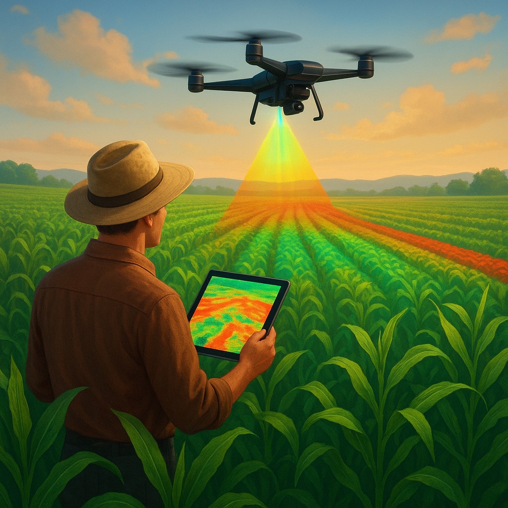
A revolution in the sky is now stripping away those blindfolds. By using agricultural drones equipped with multispectral sensors, we are entering an era of "plant whispering" through physics. These machines do not just take pretty pictures; they capture specialized light waves that reveal the health of a plant's internal cells. This technology allows us to see the invisible signals of distress weeks before a single leaf changes color, turning agriculture from a game of damage control into a precise, surgical science.
The Secret Language of Reflected Light
To understand how a drone can see a problem that a human cannot, we have to rethink what a plant actually is. To us, a leaf is a green object. To a physicist, a leaf is a sophisticated optical filter. When sunlight hits a leaf, the plant does not use all of it. It greedily absorbs blue and red light to power photosynthesis, but it reflects much of the green light, which is why we see it as green. However, there is a whole spectrum of light just beyond our vision called Near-Infrared (NIR) that plants interact with in a very specific way.
Healthy plants reflect a high amount of NIR light because of how their internal cells, specifically the "spongy mesophyll" or the airy middle layer of the leaf, are organized. When a plant is thriving, its cells are plump with water and neatly arranged, acting like a mirror for infrared energy. The moment a plant becomes stressed, whether from a lack of nitrogen, a thirsty root system, or a fungal infection, that internal structure begins to collapse. Crucially, this structural "sagging" happens long before the chlorophyll breaks down and the leaf turns yellow.
A multispectral camera on a drone captures these NIR waves alongside standard colors. By comparing how much red light a plant absorbs versus how much infrared light it reflects, we can calculate its health. The most common tool for this is the Normalized Difference Vegetation Index (NDVI). If the NDVI value drops, it means the plant is no longer reflecting infrared light efficiently, signaling trouble. It is essentially a biological early-warning system that travels at the speed of light.
Moving Beyond the Traditional Color Palette
A standard camera, like the one on your smartphone, uses a sensor that mimics the human eye using Red, Green, and Blue (RGB) filters. While great for snapshots, RGB is effectively deaf to the data a farmer needs most. Multispectral imaging adds extra "bands" of light detection. These often include the "Red Edge," a narrow band between visible red and near-infrared that is incredibly sensitive to changes in a plant's green pigment.
| Sensor Type |
Wavelengths Captured |
Primary Use Case in Agriculture |
| Standard RGB |
Red, Green, Blue |
Basic scouting, counting plants, and spotting obvious damage. |
| Multispectral |
Red, Green, Blue, Red Edge, Near-Infrared |
Early stress detection, nutrient mapping, and growth analysis. |
| Thermal |
Heat (Long-wave Infrared) |
Finding irrigation leaks and timing water needs perfectly. |
| Hyperspectral |
Hundreds of narrow bands |
Identifying specific diseases or chemical makeup (Advanced). |
By layering these data points, drones create a "prescription map." Instead of a simple photo, the farmer receives a digital heat map where the field is divided into tiny zones. Areas in deep green are thriving, while yellow or red patches highlight spots where the plants are struggling internally. This allows a farmer to look at a 500-acre plot and realize that only a specific 2-acre corner needs nitrogen. Without the drone, they might have fertilized the entire 500 acres, wasting thousands of dollars and risking chemical runoff into local streams.
The Surgical Shift in Field Management
The true power of this technology lies in treating a field not as a single block of land, but as a collection of thousands of individual patients. Historically, farming has relied on "broadcast" methods. If you suspect an insect problem, you spray the whole field. If the soil seems dry, you turn on the massive irrigation system for the entire area. This is the equivalent of a doctor giving an entire city an antibiotic because three people have a cough. It is inefficient, expensive, and hard on the environment.
With multispectral data, drones facilitate "Variable Rate Application" (VRA). This data is uploaded into a smart tractor or a specialized spraying drone. As the machine moves through the field, it automatically adjusts its nozzles. It might apply a heavy dose of fertilizer in a nutrient-poor patch, a lighter dose in a healthy area, and none at all in a section that is already saturated.
This approach significantly shrinks the "environmental footprint" of a farm. Nitrogen runoff is a major cause of water pollution and "dead zones" in the ocean. By only putting nitrogen where the data says it is needed, we prevent excess chemicals from washing away in the rain. Similarly, water conservation becomes a high-tech process. Farmers can see exactly when a crop begins to wilt internally, allowing them to provide water at the perfect moment without wasting a single gallon.
The Human Element in the Data Loop
Despite the "magic" of seeing invisible light, a drone is a scout, not a doctor. A multispectral map can tell a farmer that a plant is stressed, but it cannot always tell them why. A dip in infrared reflection looks very similar whether the plant is being eaten by bugs, suffering from root rot, or simply covered in dust from a nearby road.
This is where "ground truthing" comes in. The drone identifies the location, which saves the farmer hours of aimless walking. Instead of scouting the entire field, the farmer can walk directly to the "red spots" on the digital map to inspect them. They might flip over a leaf and find pest eggs, or dig a small hole to find compacted soil. The drone provides the coordinates, but the human provides the diagnosis.
This partnership between drones and human expertise is what makes modern ag-tech so effective. It does not replace the farmer; it gives the farmer "superpowers." It allows one person to monitor thousands of acres with a level of detail that used to require a small army of inspectors. It also changes the stress of the job. Instead of constantly reacting to fires after they have started, farmers can operate with calm, controlled oversight.
A Future Filtered through Infrared
As this technology becomes more affordable and the AI used to analyze images grows smarter, "blanket" farming will become a memory. We are moving toward a world where every drop of water and every ounce of nutrient is delivered with pinpoint accuracy. This is about more than just saving money; it is about the global challenge of feeding a growing population with a limited amount of land.
The ability to detect stress weeks before it is visible is a massive leap in our relationship with the natural world. It proves that there is a wealth of information flowing all around us, hidden in light we cannot see. By tapping into that invisible stream, we are learning to listen to the very plants that sustain us. The next time you see a small drone buzzing over a farm, know that it isn't just looking at green leaves. It is checking the pulse of our food system, one infrared reflection at a time.