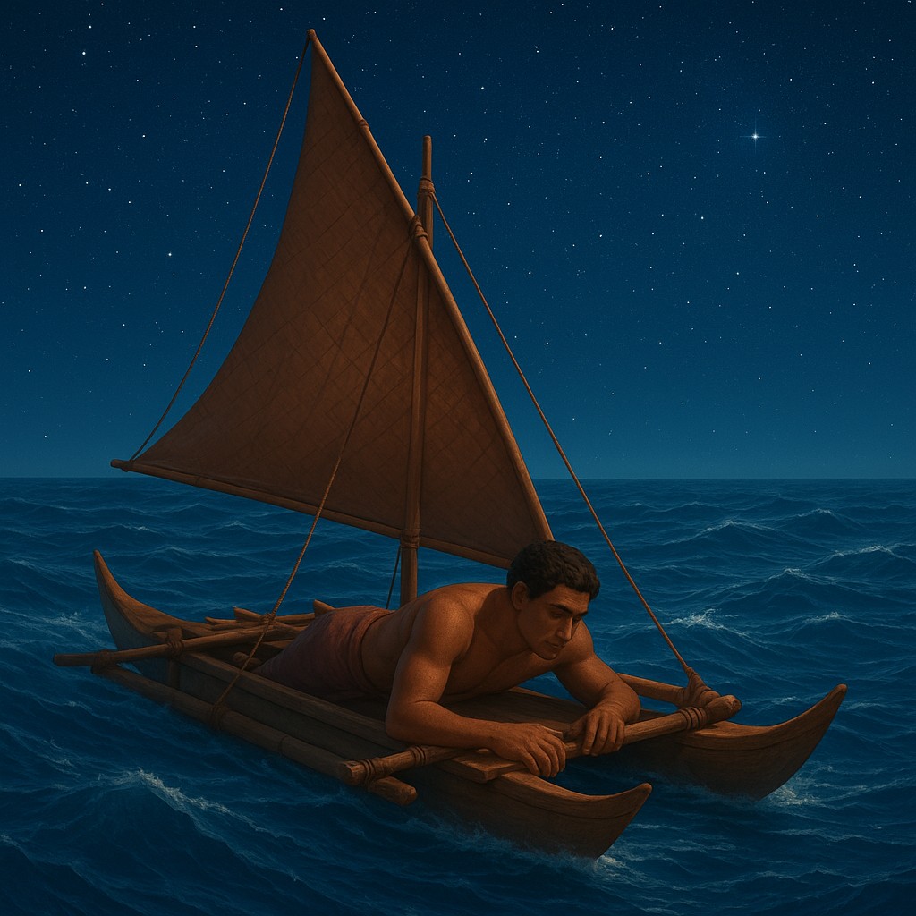
Imagine you are floating in the heart of the Pacific Ocean, thousands of miles from the nearest continent, inside a double-hulled canoe made of wood and plant fiber. Tall masts reach toward a sky thick with stars, a glittering map of the heavens. Below you, the water is a chaotic, churning mass of deep blue. There are no landmarks, no lighthouses, and certainly no satellites. To an untrained traveler, the waves are just noise - a repetitive, dangerous motion threatening to toss the boat off course. But for a Polynesian navigator, this watery expanse is not a void; it is a highly detailed, living manuscript. By lying down in the belly of the ship, these master wayfinders could feel the ocean's vibrations, turning the subtle thrum against the hull into a precise location.
This ancient art of navigation was not based on luck or myths. It was a rigorous, hands-on science based on how fluids and waves behave. Long before Western scientists measured how waves bounce off solid objects, Pacific islanders were using the ocean surface as a massive physical laboratory. They understood that every island, no matter how small or flat, leaves a permanent "fingerprint" on the surrounding water. By learning to filter out the "noise" of local winds and storms, a navigator could detect the "signal" of a distant landmass. They did this by reading interference patterns - the complex ripples created when open-ocean swells bounce off hidden shores. This is the story of how the human body became the most sensitive instrument ever used to map the sea.
The Architecture of a Moving Map
To understand how a navigator can "feel" an island hundreds of miles away, we first have to look at how the ocean itself is structured. The Pacific is rarely still. It is ruled by great, rhythmic swells that travel across thousands of miles of open water, pushed by steady trade winds. These are not the choppy, white-capped waves caused by a local breeze, but deep, powerful surges that carry immense energy. In the open sea, these swells move in a predictable direction, acting like the steady beat of a metronome. For a navigator, this main swell is the "north" on their liquid compass, providing a constant baseline for their heading.
However, the ocean is not a blank sheet of paper. When these massive swells hit an obstacle, like a volcanic peak or a coral island, something remarkable happens. The island acts like a mirror for the water's energy. As the swell hits the land, some of its energy bounces backward, while other parts of the wave bend or wrap around the edges of the land. This creates a second set of ripples that travel outward, away from the island, cutting through the main trade-wind swells. This intersection creates a "cross-hatched" pattern on the surface. This complex grid reveals the presence of land long before the island itself rises above the horizon.
Interpreting the Language of the Hull
Detecting these patterns is not a mental exercise; it is a physical one. While a modern sailor might look at a screen, a traditional Polynesian navigator would often go to the most stable part of the canoe, sometimes even lying flat on their back in the center of the hull. In this position, the navigator’s body becomes part of the boat’s wooden frame. They are searching for a specific feeling in the boat’s motion. When the canoe hits the spot where the main swell and a reflected wave meet, the boat's movement changes from a rhythmic surge to a distinct "stutter" or a twisting vibration.
This technique requires incredible focus. It is like trying to hear a single violin in the middle of a loud rock concert. The "rock concert" is the background noise of the ocean: the wind, the splashing of the wake, and the local choppy waves caused by the weather. The "violin" is the faint echo of a landmass that might be fifty miles away. Through decades of practice, navigators learned to train their nervous systems to ignore surface chatter and focus on the deep pulse of the ocean. They could tell which direction the reflection was coming from by sensing which part of the hull lifted first, essentially "pointing" toward the hidden island.
The Geometry of Oceanic Echoes
The way waves interact with islands follows predictable rules of physics. Wayfinders used three main patterns: reflection, refraction, and diffraction. Each one created a different "signature" in the water that told the navigator not just where an island was, but what kind of island it might be. For example, a high volcanic island with steep underwater cliffs reflects energy much more sharply than a low-lying coral island with a shallow, sloping reef. A navigator could tell the difference between the "hard" bounce of a cliff and the "soft" fade of a beach simply by the quality of the vibration hitting the boat.
| Wave Phenomenon |
Physical Action |
Navigator's Perception |
| Reflection |
Swells bounce directly off the coast. |
A sharp, opposing "kick" against the main swell. |
| Refraction |
Swells bend around the island's edges. |
A change in wave direction, creating a "wrapping" sensation. |
| Diffraction |
Waves spread out after passing through gaps. |
Low-energy "shadow zones" indicating a gap between islands. |
| Interference |
Two or more wave patterns collide. |
A "knocking" or rough texture in the hull's vibration. |
Refraction, or bending, was a vital tool for finding tiny targets in a vast ocean. As a swell nears an island, the parts of the wave closest to the shore slow down because they rub against the rising seafloor. Meanwhile, the parts in deeper water keep moving at full speed. This causes the wave front to "wrap" around the island, almost as if it were hugging it. If a navigator was on the "lee" (sheltered) side of an island, they could detect these wrapped waves coming from both the left and the right. Where these two bent patterns met, they created a unique, standing wave known as the dilep. To a trained navigator, finding the dilep was like finding a paved highway leading straight to the center of the island.
The Secret Architects of Stick Charts
Because this knowledge was so complex and took a lifetime to master, navigators in the Marshall Islands developed a unique way to map these invisible forces: the stick chart. Unlike Western maps, which focus on fixed distances, stick charts (known as rebbelib, meddo, or mattang) were teaching tools made of coconut sticks and fiber. The sticks did not represent paths for ships. Instead, they showed the structure of the ocean swells themselves. Small shells were tied to the intersections to represent islands, while the curved sticks showed how the waves bent.
Crucially, these charts were never taken out to sea. They were used on land to teach students how the ocean behaved. Once a navigator set sail, the map stayed in their mind. This shows a deep difference in philosophy: in the West, a map is an object that tells you where you are; in Polynesia, the map is an internal understanding of how the world moves. By memorizing the "shapes" of the water around every known island, the navigator turned the entire Pacific into a familiar neighborhood where every vibration was a signpost.
Sifting Signal from Noise
The biggest challenge to this method is the massive amount of "noise" in the environment. On a stormy day, the surface of the water is a mess of whitecaps and chaos that would seem to drown out any subtle echoes. However, the brilliance of the Polynesian system was their understanding of "wave periods." Reflected swells tend to have different timing than local wind waves. Local waves are short and "choppy," while deep-ocean swells have long, powerful rhythms. By focusing on the long-period energy, a navigator could look "past" the storm to see the underlying truth of the ocean.
This skill was often tested in "blind" conditions. Legends say that master navigators would sometimes be taken to the middle of the ocean during a storm or on a pitch-black night and challenged to find their way home based only on the feel of the hull. The navigator would lie down, wait for the distractions of the surface to settle in their mind, and listen for the "hollow" sound of a wave shadow or the rhythmic "clack" of an interference pattern. It was a form of meditation that required absolute calm in the face of nature’s fury. This ability to find order in chaos is perhaps the most profound lesson these wayfinders offer us today.
Navigating the Modern World with Ancient Eyes
In our age of digital certainty, where a blue dot on a smartphone tells us exactly where we are, it is easy to see these ancient methods as simple relics. But doing so ignores how sophisticated the human mind can be. Polynesian navigators were doing in their heads what we now use supercomputers for: calculating fluid dynamics, complex geometry, and data from multiple sensors. They didn't just find islands; they understood how the physical world is interconnected. They knew that an event in one place (a wave hitting a distant shore) creates a ripple that can be detected thousands of miles away.
The story of the wayfinders reminds us that we are all born with sensitive biological tools that we often forget to use. Whether it is a doctor feeling a subtle rhythm in a heartbeat or an engineer sensing a tiny vibration in a bridge, the "felt" world offers a wealth of information just beneath the surface. If we can learn to quiet the noise of our busy lives and focus on the deep swells of information around us, we might find that, like the navigators of old, we are never truly lost. The map of where we need to go is already written in the world around us; we simply need to learn how to feel it.