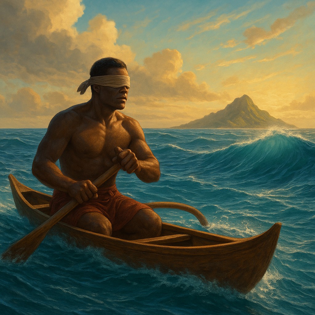
Imagine being blindfolded, spun around, and dropped into the center of a massive soccer stadium during a championship match. You cannot see the players, the ball, or the goalposts. Yet, you are expected to walk straight to the center circle using nothing but the faint vibrations of the cheering crowd and the slight shift of the wind against your skin. For thousands of years, the master navigators of the Pacific performed a feat even more incredible. They crossed the vast wilderness of the open ocean, traveling between tiny specks of land separated by thousands of miles of deep blue water - all without a compass, a sextant, or GPS. While modern sailors depend on silicon and satellites, these ancient explorers relied on a "biological computer" tuned to the rhythmic language of the sea.
Their secret was not a mystical "sixth sense" or a lucky guess; it was a disciplined, scientific mastery of fluid dynamics. They did not see the ocean as a flat, empty surface, but as a map of constant motion. Every wave had a name, a personality, and a history. By sitting at the front of a canoe and feeling how the hull pitched and rolled, a navigator could "see" an island that was still far below the horizon. They were reading "wave shadows" - the subtle echoes created when the steady pulse of the open ocean hit the solid mass of an island. This skill is one of the most sophisticated examples of environmental awareness in human history, turning the entire Pacific into a readable landscape of peaks, valleys, and shadows.
The Constant Rhythm of the Deep Sea
To understand how a navigator finds land by feeling waves, we first have to understand "swells." Unlike the choppy, messy waves caused by local winds, swells are the long-distance travelers of the sea. They are born from massive storms thousands of miles away, rolling across the planet with a steady beat and direction. These swells act like a metronome for the ocean. In much of the Pacific, the trade winds create a primary swell that can last for weeks or months, moving predictably from the northeast to the southwest. When a navigator sets out, their first job is to identify this "house swell" - the background music of the deep sea against which all other movements are measured.
This primary swell is the navigator’s North Star. As long as the boat maintains a steady angle to that rhythmic pulse, the navigator knows their heading. However, the ocean is rarely a single wave pattern. There are often two, three, or even four different swell systems overlapping at once, coming from different corners of the horizon. A master navigator can tell them apart, mentally filtering out the "noise" of local wind waves to focus on the deep, powerful pulses of distant storms. They often describe this feeling as a specific "knot" or "jolt" in the boat’s motion. If the main swell hits the side of the boat while a secondary swell hits the front, it creates a complex dance. Learning to identify these distinct layers of motion is the first step in ancient Pacific navigation.
The Architecture of a Wave Shadow
When a steady ocean swell hits an island, it doesn’t just stop. It behaves much like light hitting an object or sound hitting a wall. The island acts as a barrier, and as the swell passes it, several physical changes occur. The most important is refraction. As a wave hits shallow water around an island, the part of the wave closest to land slows down because of friction with the seafloor. Meanwhile, the part of the wave still in deep water keeps its speed. This causes the wave front to bend, or "wrap around," the island.
Think of a runner going around a tight curve on a track; their inner leg moves slower while their outer leg swings wide. As the wave wraps around both sides of an island, the two bent waves eventually meet on the "lee" side - the side protected from the wind. Where these two bent waves cross, they create a unique crisscross pattern known as a "backwash" or a "standing wave." This interference pattern is like a flashing neon sign for a navigator. Even if the island is nowhere in sight, the way the boat begins to kick and shudder tells the navigator they have entered the "shadow" of land. They aren't looking at the island; they are looking at the island’s signature in the water.
Navigational Tools of the Body and Mind
It is a common mistake to think these navigators were just "winging it" or using vague intuition. Their training was intense, often starting in childhood and lasting for decades. In the Marshall Islands, this knowledge was recorded in "stick charts." These were not maps in the usual sense, but memory aids made from coconut branch ribs and small shells. The sticks showed the major swell patterns, and the shells represented islands. A navigator would study these charts on land to memorize the complex geometry of how waves bend and bounce before ever stepping onto a boat. Once at sea, the chart stayed on land; the map was held entirely in the navigator’s mind.
The most sensitive tool on the boat was the navigator’s own body. To better feel the boat’s motion, master navigators would often lie down in the bottom of the canoe - sometimes even on their backs - to feel vibrations through their center of gravity. In this position, the inner ear and the nerves in the skin become highly sensitive. They could tell the difference between the "slap" of a local wind wave and the "thud" of a swell that had bounced off a distant reef. This transformed the human nervous system into a high-precision sensor, capable of feeling changes in wave height and timing that an untrained person would never notice.
| Feature |
Primary Swell |
Refracted Wave |
Reflected Wave |
| Origin |
Distant storms (thousands of miles away) |
Primary swell bending around land |
Waves "bouncing" off a cliff or reef |
| Predictability |
Very steady over long periods |
Predictable based on island shape |
Sharp and irregular |
| Navigational Use |
Keeping a steady Compass heading |
Measuring distance to unseen land |
Finding specific nearby hazards |
| Physical Feeling |
Steady, rhythmic rocking |
A diagonal "shimmy" or crisscross |
Short, choppy, upward jolts |
Identifying the Signs of Land
Beyond the wrapping of waves, navigators looked for "the sea that talks." When a swell hits land directly, some of its energy bounces straight back out to sea, like a ball hitting a wall. This creates a "clapotis" - a standing wave where the incoming swell and the reflected wave collide. This collision creates a distinct, peaked wave that doesn't travel in any direction but just jumps up and down. To a navigator, feeling this vertical "hop" in the boat is a signal that land is straight ahead, even if it is forty or fifty miles away.
There is also the "dead water." This happens directly behind an island, where the land has blocked the swell completely, creating a wedge of calm water. If a boat has been laboring through heavy swells for days and suddenly enters a zone where the rhythmic rolling stops - but the wind is still blowing - the navigator knows they are downwind of an island. By finding the edges of this calm zone, they can figure out how wide the island is and steer toward it. These aren’t just subtle clues; they are loud, physical changes that tell the crew exactly what to do.
Correcting the Myth of "Instinct"
When Western explorers like Captain Cook first met Polynesian navigators, they were confused. They couldn't understand how people without magnetic compasses or clocks could find tiny islands in the middle of five million square miles of ocean. This led to a patronizing myth that Pacific Islanders had an "animal instinct" or a supernatural connection to the sea. However, modern research has proven the opposite. This was a system of logic, math, and physics. It was an intellectual achievement as great as the invention of calculus or astronomy.
The "instinct" was actually a form of deep literacy. Just as a modern person can "instinctively" read a sentence without sounding out every letter, a navigator could "read" the ocean. This required a massive amount of memorized information. A navigator had to know the typical swell patterns for every season, the locations of hundreds of islands, and the specific "shadow" each island cast. If the wind shifted or the season changed, the "map" changed with it. This was an active, thinking process of constant adjustment. If the boat’s motion didn't match the expected pattern, the navigator had to figure out why, often staying awake for days to ensure the boat didn't drift off course.
The Lessons of Extreme Perception
The story of wave shadows teaches us something deep about human potential. Today, we often assume that if a task is hard, we need a machine to do it. We use GPS to find the store and apps to tell us if it’s raining. But ancient navigators show us that the human brain is capable of incredible precision when it is deeply connected to its environment. When we let screens do our thinking for us, we lose the ability to see the patterns in the world around us. These navigators didn't just survive on the ocean; they were in constant conversation with it.
This level of mastery also shows the importance of passing down knowledge. The system of wave navigation was so complex it could only survive if elders taught the youth through song, story, and hands-on apprenticeship. When these chains are broken, the "technology" is lost just as surely as if a hard drive were erased. Fortunately, in places like Hawaii and the Marshall Islands, a new generation is reclaiming this science, proving that the ancient ways of reading the water are still as accurate today as they were three thousand years ago.
You may never find yourself in a wooden canoe in the middle of the Pacific, but you can still apply this mindset to your own life. The next time you face a difficult problem, instead of looking for a quick tech-based solution, stop and look for the "shadows." Look for the subtle breaks in the patterns of your work, your relationships, or your surroundings. Everything that exists - from an island in the sea to a shift in someone's mood - leaves a trail and creates an echo. If you can learn to quiet the noise and feel the underlying rhythm, you might find that the map you need is already right beneath your feet.