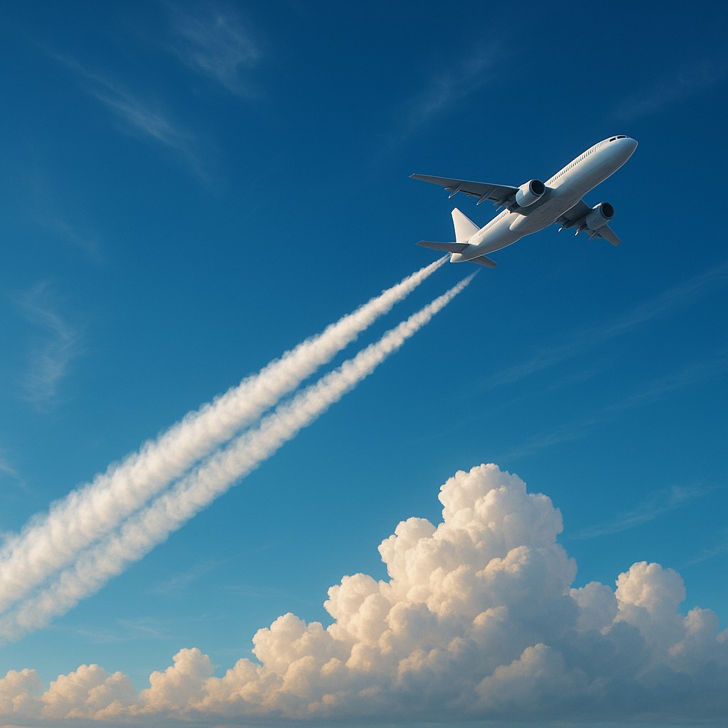
When you look up at a clear blue sky and see a crisp white line trailing behind a jet, it is easy to assume you are just witnessing a harmless trail of steam or a hallmark of modern travel. For decades, we viewed these condensation trails, or "contrails," as nothing more than a visual byproduct of jet engines, much like the exhaust from a car on a cold winter morning. However, as our understanding of atmospheric physics has deepened, scientists have discovered that these fleeting streaks do much more than just decorate the horizon. They act like a thin, artificial blanket that traps heat radiating from the Earth, contributing significantly to global warming in a way that has nothing to do with carbon dioxide emissions.
The fascinating part of this story is that not every flight creates a long-lasting contrail. The atmosphere is a complex, layered cake of different temperatures and moisture levels. For a contrail to form and stay put, an aircraft must fly through a specific kind of air known as an ice-supersaturated region. If a pilot could simply nudge the plane a few thousand feet higher or lower, they could bypass these "sticky" patches of air entirely, preventing the heat-trapping clouds from ever forming. This realization has sparked a revolution in flight planning, leading to real-world trials where satellite data and humidity sensors are used to "steer" planes away from these invisible climate traps.
The Secret Life of Artificial Clouds
To understand why a simple white line matters so much, we have to look at the physics of the upper atmosphere. When jet engines burn fuel, they release water vapor and tiny soot particles. If the surrounding air is cold and humid enough, that water vapor quickly freezes onto the soot, creating billions of tiny ice crystals. In most cases, these crystals evaporate within minutes. But when a plane enters an ice-supersaturated region (ISSR), the air is already holding more moisture than it normally can. In these zones, the ice crystals do not evaporate; instead, they grow and spread, eventually forming "contrail cirrus" clouds that can linger for several hours and stretch across dozens of miles.
The climate impact of these clouds is a double-edged sword. During the day, they reflect some incoming sunlight back into space, which has a slight cooling effect. However, their primary role is acting as an insulator. They trap the heat that the Earth tries to release at night. Because most flights occur during the day but their contrails last well into the evening, the net result is a significant warming of the planet. In fact, some atmospheric models suggest that the warming caused by contrails is roughly equal to the warming caused by all the CO2 ever emitted by the aviation industry. This means that if we can stop contrails from forming, we can instantly cut the climate footprint of a flight by nearly half.
What makes this a "low-hanging fruit" in climate science is how quickly the problem disappears. Unlike carbon dioxide, which stays in the atmosphere for centuries, a contrail is gone in a few hours. If we change a flight path today to avoid a contrail, the warming potential of that flight drops immediately. We do not have to wait decades for the atmosphere to recover. This has led to a surge in interest from airlines and tech companies who realize that a tiny change in altitude could be one of the most effective environmental tools we have. It is a rare instance where a small operational tweak yields a massive, near-instant benefit for the planet.
Navigating the Invisible Map of Humidity
The challenge in avoiding these regions is that they are invisible to the naked eye and traditional radar. An ice-supersaturated region is not a storm or a thick cloud; it is a pocket of clear air that happens to be extremely humid. To avoid them, pilots need a high-definition map of the moisture layers in the sky. This is where modern satellite technology and advanced weather modeling come into play. Groups like Google Research, Breakthrough Energy, and various international aviation authorities are currently testing systems that combine satellite imagery with weather forecasts to predict exactly where these zones will appear.
During recent trials, researchers have used past data and real-time satellite feeds to tell pilots to adjust their cruising altitude by as little as 2,000 feet. By dipping just below or climbing just above a moist layer of air, the aircraft enters a region where the air is "ice-subsaturated," meaning any ice crystals formed will evaporate almost instantly. These trials have shown remarkable success. In certain test areas, flights reduced contrail formation by over 50 percent simply by making minor adjustments to their altitude. It is like a high-altitude game of "the floor is lava," where pilots try to avoid specific horizontal slices of the sky to keep the atmosphere clear.
However, the atmosphere is never still. These humid regions move, grow, and shrink based on wider weather patterns, such as storms over the Atlantic or the jet stream. This requires a constant stream of data. Some aircraft are now being equipped with specialized humidity sensors that act as "scouts," feeding real-time data back to ground control to update the maps for planes following behind. This collaborative approach turns the entire global fleet into a giant sensory network, mapping the invisible architecture of the sky to ensure the easiest path is also the cleanest.
The Mathematical Balancing Act of Fuel and Physics
If avoiding contrails is so effective, you might wonder why we do not do it for every single flight. The answer lies in a delicate trade-off involving fuel consumption. Airplanes are designed to fly at specific altitudes where the air density is best for their engines and wings. If a pilot has to stay at a lower altitude to avoid a humid patch, the air is thicker, creating more drag and forcing the engines to burn more fuel. Burning more fuel means releasing more CO2. This creates a "climate ledger" where we have to balance the immediate warming of a contrail against the long-term warming of additional carbon emissions.
To make this work, flight planners use complex programs to determine if a detour is worth it. If a 2,000-foot altitude change increases fuel use by 1 percent but prevents a contrail that would have caused ten times that much warming, the trade-off is a clear win for the environment. Most studies suggest that only a small percentage of flights (about 10 to 15 percent) are responsible for the vast majority of long-lasting contrails. By targeting only these "big fish" flights, the industry can achieve massive cooling benefits with a negligible increase in total fuel use. The goal is not to redirect every plane, but to surgically adjust the few that are in the wrong place at the wrong time.
| Factor |
Persistent Contrail Path |
Contrail-Free Path |
| Atmospheric Condition |
Ice-Supersaturated Region (ISSR) |
Ice-Subsaturated Region |
| Visual Evidence |
Long-lasting, spreading white lines |
No trail or short-lived "puffs" |
| Climate Impact |
Traps Earth's heat (Warming) |
Minimal heat trapping |
| Fuel Efficiency |
Optimal (Usually original flight level) |
Variable (Slightly higher burn due to drag) |
| Persistence |
Can last for hours and turn into clouds |
Disappears in seconds or minutes |
This balancing act is also influenced by the time of day. A contrail formed at night is purely a warming agent because there is no sunlight to reflect. Conversely, a contrail formed in the early morning might actually have a slight cooling effect by reflecting the sun's rays before the Earth has fully warmed up. Sophisticated software must account for the sun's angle, the thickness of the potential contrail, and the ground below to decide if a detour is beneficial. It is a complex puzzle where the right answer changes every hour, requiring a level of computing power that was simply unavailable to flight planners just a decade ago.
Integrating Strategy into the Global Air Traffic Grid
Moving from successful trials to a global standard is no small feat. The sky is already a crowded place, and air traffic controllers are tasked with keeping thousands of planes at safe distances from one another. If every pilot suddenly wants to change altitude to avoid a humid patch, the potential for chaos is high. For contrail avoidance to become a standard part of aviation, it must be built into existing traffic management systems. This means that humidity data needs to be as fundamental to a flight plan as wind speeds and turbulence reports.
One way this is being addressed is through automation. Instead of a pilot calling a controller to ask for a change, flight planning software can suggest a "climate-optimized" route before the plane even takes off. If the route is approved as safe and clear of other traffic, it becomes the default path. In regions like the North Atlantic, where planes follow strict "tracks" to manage high traffic, researchers are looking at how to shift entire tracks by a few thousand feet to avoid humid zones. This broad approach could clear the skies of contrails without requiring individual pilots to make constant manual adjustments.
The economic side of the equation is also shifting. As carbon markets grow and airlines face more pressure to report their total impact on the climate, there is a financial reason to avoid contrails. Governments and international bodies are beginning to discuss incentives for airlines that actively minimize these non-CO2 impacts. By turning atmospheric care into a measurable goal, the aviation industry is moving toward a future where "clean flying" refers to the clarity of the air behind the wing as much as the fuel inside the tank.
Addressing Myths and Refining the Science
As with any emerging science, there are several misconceptions about contrail avoidance. A common myth is that all white lines in the sky are bad for the environment. In reality, a short-lived contrail that disappears as fast as it forms is essentially harmless. The focus is strictly on the long-lasting ones that turn into clouds. Another misconception is that this is a "cheaper" alternative to switching to sustainable aviation fuels. In truth, we need both. While contrail avoidance addresses immediate warming, sustainable fuels and new engine designs are necessary to stop the long-term buildup of CO2.
There is also the question of "over-correction." Some critics worry that if we avoid contrails too aggressively, we might increase fuel use across the board, leading to a worse result. This is why using satellites to verify the results is so important. By observing whether a predicted contrail actually formed or was successfully avoided, scientists can improve their models. This feedback loop ensures that we are using real evidence to prove the fuel trade-off was worth it. We are also learning more about how contrails interact with natural clouds. Sometimes, a contrail will form inside an existing cloud where its impact is much lower. Learning to spot these differences is the next frontier in managing our skies.
The beauty of this field is that it is constantly evolving. Every year, satellite sensors improve and climate models become more detailed. We are moving away from a "one size fits all" approach toward a data-driven flight experience. The ultimate goal is a sky where aviation's impact is minimized through a combination of better fuels, smarter engines, and a deep respect for the atmospheric layers we travel through. By treating the sky as a complex system rather than just an empty void, we can ensure that our desire to explore the world does not come at the cost of the planet itself.
The Future of the High-Altitude Horizon
The journey toward contrail-free flight is an inspiring example of how human ingenuity can adapt to environmental challenges. It reminds us that sometimes the solution to a massive problem is not a total overhaul of technology, but a smarter way of using what we already have. By listening to the data hidden in the humidity and temperature of the upper atmosphere, we are learning to fly in harmony with the weather rather than just through it. This shift turns every pilot and flight planner into a guardian of the atmosphere, making the "invisible" consequences of travel visible and manageable.
As these trials become standard practice, we can look forward to a future where the sky remains a deep, uninterrupted blue. This is not just about looks; it is about a measurable, rapid reduction in our impact on the planet's temperature. The next time you look up and see a plane crossing the sky without leaving a trace, you might be looking at the result of a complex calculation and a pilot’s careful touch. It is a silent victory for science and a testament to our ability to innovate our way toward a cooler, clearer horizon. There is a profound sense of hope in knowing that by simply moving a little bit, we can change a lot.