<h2>How do self-driving cars "see" the road? A friendly tour of sensors, smarts, and surprises</h2>
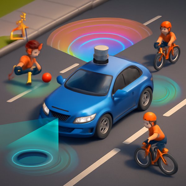
Imagine sitting in a car that drives itself while you sip coffee, scroll through a message, or stare out the window thinking about nothing in particular. Now imagine that car has to notice a child chasing a ball, a pothole filled with water, a lane closed for construction, and a bicyclist weaving between cars, all while keeping everyone safe. How does the car "see" those things? It does not have eyes like yours, but it has a set of technological senses and a brain trained to interpret them. The result is part hardware orchestra, part advanced pattern recognition, and a lot of careful engineering to handle messy, real-world situations.
This article will take you from simple analogies to the nuts-and-bolts of sensors, perception algorithms, mapping, and decision making. You will learn the roles of cameras, lidar, radar, and software, find out where these systems still struggle, and leave with practical questions and small challenges that make the learning active and memorable. Expect clarity, gentle humor, and a few "aha" moments.
<h3>Seeing versus understanding - what self-driving cars actually do</h3>
When people say a car "sees," it usually means the vehicle senses its environment and forms an internal picture good enough to make safe driving decisions. That picture has several layers. First, raw sensor data - images, point clouds, echoes - arrive like a choir singing different notes. Second, software cleans and aligns those notes through calibration and synchronization. Third, machine learning and classical algorithms interpret the cleaned data to detect objects, estimate their motion, label drivable space, and predict what will happen next. Finally, planning and control modules decide how to steer, brake, or accelerate.
A useful analogy is how humans drive: your eyes collect light, your brain recognizes objects and infers intentions, and your body acts. For autonomous cars, sensors replace eyes; perception algorithms replace some parts of your brain; planning and control replace muscular responses. But unlike humans, cars can measure distances in meters precisely, detect relative velocities directly with radar, and fuse inputs from multiple sensor types to reduce ambiguity. They also have limitations that human intuition can sometimes outshine.
<h3>Meet the sensor team - the car's senses and what each one contributes</h3>
Self-driving cars typically use a combination of sensors, because each sensor has different strengths and weaknesses. Here is a compact table to keep the main players straight:
<table>
<tr>
<th>Sensor</th>
<th>What it returns</th>
<th>Strengths</th>
<th>Weaknesses</th>
</tr>
<tr>
<td>Camera</td>
<td>Color images, high resolution</td>
<td>Detailed appearance, read signs, classify objects</td>
<td>Suffers in low light, glare, and fog; no direct depth</td>
</tr>
<tr>
<td>Lidar</td>
<td>3D point cloud, distance for each laser pulse</td>
<td>Precise geometry, works day and night, good at shape</td>
<td>Expensive, reduced performance in heavy rain, snow, dust</td>
</tr>
<tr>
<td>Radar</td>
<td>Distance and relative velocity via radio waves</td>
<td>Robust in adverse weather, measures speed directly</td>
<td>Lower spatial resolution, coarse object shape</td>
</tr>
<tr>
<td>Ultrasonic</td>
<td>Short-range echo for nearby objects</td>
<td>Cheap, useful for parking</td>
<td>Very short range, not for highway use</td>
</tr>
<tr>
<td>GPS / GNSS, IMU, wheel odometry</td>
<td>Own position, motion estimates</td>
<td>Global position, orientation, short-term motion tracking</td>
<td>GPS drift in urban canyons, IMU noise accumulates</td>
</tr>
</table>
Think of cameras as the car's eyes that provide visual detail, lidar as a 3D scanner that builds geometric depth maps, radar as the hearing that senses speed and range through poor visibility, and ultrasonic as the sense of touch for nearby obstacles. GPS and IMU tell the car where it thinks it is on the map.
<h3>Cameras: high-resolution eyes that love signs and textures</h3>
Cameras provide RGB images that are excellent for recognizing shapes, colors, and semantic details, such as traffic signs, lane markings, and whether an object is a pedestrian, bicycle, or truck. Computer vision models, especially convolutional neural networks, have become very good at using visual patterns to detect and classify objects in images. A camera can tell you that a shape looks like a stop sign or that the color pattern matches a pedestrian wearing a reflective jacket.
However, cameras have weaknesses that people intuitively understand - glare at sunrise, deep shadows, and heavy fog can hide visual cues. Cameras do not directly measure distance, so the software must estimate depth either via stereo camera setups or by fusing camera output with lidar or radar. A tempting misconception is that cameras alone are enough for full autonomy; companies like Tesla favor camera-heavy stacks, but many others combine sensors to increase robustness.
<h3>Lidar: the 3D flashlight that builds a geometric world</h3>
Lidar stands for light detection and ranging. It sends laser pulses and measures how long they take to return, creating a point cloud where every dot represents a reflection in 3D space. This gives a very direct measurement of shape and distance, which simplifies tasks like detecting the exact edge of a curb, the profile of a pedestrian, or the geometry of a parked car. Lidar excels at night, and at providing accurate spatial layouts that are easy for algorithms to use.
Lidar is not magical. Its performance can degrade in heavy rain, fog, or dust, because particles scatter the laser light. Early lidar units were also expensive, though prices are coming down. For mapping and precise localization, lidar is a powerful tool; for rapid object recognition by appearance, cameras still shine.
<h3>Radar and ultrasonic - the robust partners for velocity and proximity</h3>
Radar uses radio waves and measures how those waves bounce back to estimate distance and relative velocity using the Doppler effect. Radar is especially valuable at detecting moving objects in poor visibility, and it directly measures speed without relying on frame-to-frame image analysis. This makes radar a great complement for judging closing speeds on highways or for collision avoidance.
Ultrasonic sensors are low-cost echoes used at very short range, typically for parking and detecting close obstacles. They are not used for high-speed navigation, but they are practical for slow maneuvers where precise inches matter.
<h3>Sensor fusion - why multiple senses beat a single sense</h3>
The magic in modern autonomous driving is not just having sensors, but combining them so that the weaknesses of one are covered by the strengths of another. Sensor fusion aligns camera images, lidar point clouds, and radar returns into a consistent story about the scene. When calibration and time synchronization are done right, cameras can label the semantic content of an object while lidar provides exact geometry and radar confirms velocity. This reduces false positives and increases confidence in critical decisions.
Fusion is nontrivial. Sensors have different sampling rates, coordinate frames, and noise characteristics. Developers use mathematical frameworks like Kalman filters, particle filters, and probabilistic graphical models to merge uncertain measurements into reliable estimates. The result is an internal model that lists objects, their positions, velocities, and predicted future paths, all with confidence scores.
<h3>From perception to prediction - how the car reasons about moving things</h3>
Detecting objects is only step one. The car must track objects over time and predict what they will do next. Tracking uses algorithms that associate new detections with previous tracks, smoothing noisy positions and estimating velocities. Prediction models range from simple physics - assume constant velocity - to learned models that use behavior patterns: pedestrians tend to cross at crosswalks, a bicyclist may swerve, cars often follow lanes.
Machine learning plays a big role here. Sequence models and recurrent networks can anticipate trajectories based on context: nearby vehicles, lane geometry, and traffic signals. Prediction is one of the trickiest aspects because human behavior can be spontaneous and context-dependent. The car therefore includes safety margins and conservative fallback behaviors when uncertainty is high.
<h3>Localization and maps - how a car knows exactly where it is</h3>
Knowing what is around you is only useful if you know where you are. Self-driving cars localize using a mix of GPS, inertial measurements, wheel odometry, and map matching. For high-precision tasks, companies use high-definition maps that include lane-level detail, traffic sign locations, and 3D geometry. The car compares its sensor data, especially lidar point clouds and camera landmarks, to these maps to achieve centimeter-level accuracy.
Simultaneous Localization and Mapping - SLAM - is an algorithmic approach where a vehicle builds or updates a map while locating itself in it. SLAM is more common in robotics and mapping tasks; in deployed autonomous fleets, pre-built HD maps plus robust localization pipelines are more common for reliable operation in specific areas.
<h3>Planning and control - turning perception into motion</h3>
Once the world is perceived and future behaviors are predicted, the planning module decides the safest and most comfortable path through the scene. Planning includes route planning, behavior planning (yield, overtake, stop), and motion planning, which is the detailed trajectory the vehicle will follow. Planners optimize objectives like safety, passenger comfort, and obeying traffic rules, often balancing competing goals with cost functions.
Control systems then translate planned trajectories into steering, throttle, and braking actions. These controllers are tuned for smoothness and responsiveness, and they must act faster than people expect - braking loops can be on the order of milliseconds. Importantly, safety systems monitor sensors and planners to apply emergency braking or hand control back to a human if something goes wrong.
<h3>Real-world stories - how companies and events shaped the technology</h3>
The modern push for autonomous vehicles traces back to milestones like the DARPA Grand Challenge in the early 2000s, where robotic vehicles first navigated complex off-road courses. Since then, companies like Waymo, Cruise, and Zoox pursued fleets with lidar-equipped stacks and exhaustive mapping, enabling safe urban driving in limited areas. Other players, such as Tesla, have pushed a camera-first strategy that leans heavily on vision and large-scale fleet data to train perception models.
A practical case study is how Waymo uses lidar and HD maps to achieve consistent urban autonomy in select cities. Their approach emphasizes redundancy and conservative behavior when uncertainty arises. Tesla, by contrast, emphasizes scaling vision and fleet learning, aiming to handle a wide variety of roads without expensive lidar hardware. These differing philosophies show that the industry is still experimenting with the best combination of senses and software.
<h3>Common misconceptions and what to believe instead</h3>
- Misconception: Self-driving cars are ready to replace human drivers everywhere right now. Reality: Autonomous systems are improving rapidly, but most are limited to specific geographies or conditions, and they still struggle with rare, unpredictable events.
- Misconception: Lidar is the only way to be safe. Reality: Lidar provides critical geometric data, but safe autonomy can be achieved with different sensor mixes, provided redundancy and robust algorithms are in place.
- Misconception: Cars "see" and "think" exactly like humans. Reality: Cars form mathematically precise estimates and probabilities, which can be more accurate in some respects and less intuitive in others.
<h3>Small challenges and "what if" questions to stretch your thinking</h3>
- What if a pedestrian is hidden behind a parked van and only steps into view at the last second - how would cameras, lidar, and radar each respond? Think through what each sensor detects first and how fusion helps.
- Imagine heavy fog reduces camera visibility to almost zero. Which sensors will the system trust more, and what cautious behaviors might it choose?
- Suppose GPS signal drops downtown. What combination of sensors and algorithms allows the car to still know its location accurately enough to proceed safely?
Try sketching scenarios and labeling which sensors help at each moment. You can do this on a napkin - it is a powerful way to internalize the different roles sensors play.
<h3>Actionable takeaways for drivers, policy makers, and curious minds</h3>
- If you use driver-assist features, understand their limits: most require driver attention and are not fully autonomous. Read the manual and stay ready to take control.
- If you care about safe deployment, support standards that require redundancy, clear testing metrics, and transparent reporting of disengagements and failures.
- For learning enthusiasts, experiment with open datasets like KITTI and nuScenes, or try simulation platforms to build perception and planning models. These tools are accessible ways to practice and contribute to the field.
<blockquote>
Autonomy is not about replacing human judgment, it is about enabling a new partnership between precise sensors and careful algorithms to make transportation safer and more accessible.
</blockquote>
<h3>The road ahead - cautious optimism and continuing surprises</h3>
Self-driving cars "see" using a coordinated team of sensors and software that together create a probabilistic understanding of the world. This system is powerful, and it has already made driving safer in many contexts, but it must still contend with messy reality - weather, unpredictable human behavior, and edge cases. The future will likely include both hardware innovations, like cheaper and better lidar, and software advances, like more robust prediction models and learning from vast amounts of driving data.
If you walk away from this guide feeling smarter and curious, you have succeeded. Keep asking "how would the car handle this?" when you see a complicated traffic situation. That exercise sharpens intuition about both the promise and the perils of autonomous driving and helps everyone be a better partner in the journey toward safer roads.