Imagine you are standing on a beach in Peru, looking out at the Pacific Ocean. Usually, the water here is bracingly cold. Deep-sea currents pull up nutrients from the bottom to feed massive schools of fish. But every few years, something strange happens around Christmas. The water turns uncharacteristically warm, the fish vanish, and the local weather starts acting erratic.
Centuries ago, local fishermen noticed this periodic warming and named it El Niño, or "The Boy Child," because it often peaked during the holiday season. What they did not realize back then was that this local warm patch was actually the heartbeat of a global climate engine that can flip the world's weather upside down.
If you have ever wondered why one winter is strangely mild while the next is a frozen nightmare, or why some years bring epic floods while others spark relentless droughts, you are likely seeing the handiwork of El Niño. It is not just a "storm" or a "weather event" that passes through in an afternoon. Instead, it is a massive shift in how the ocean and the atmosphere talk to each other. Because the Pacific Ocean covers one-third of our planet, when its temperature changes, the rest of the world has no choice but to listen. It is the ultimate domino effect: a warm breeze in the middle of the ocean can eventually lead to a price hike for coffee in London or a heatwave in Australia.
The Pacific Ocean's Internal Balancing Act
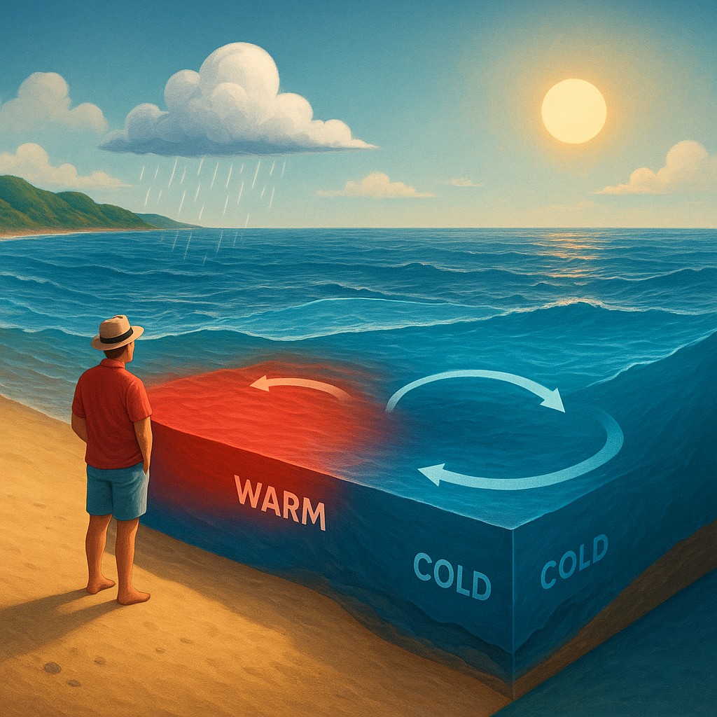
To understand why El Niño happens, we first have to understand what "normal" looks like in the Pacific. Under standard conditions, powerful trade winds blow from east to west. They push across the surface of the ocean from South America toward Asia and Australia. As these winds skim the water, they drag sun-warmed surface water along with them. This creates a massive "pile" of warm water on the western side of the ocean near Indonesia. In fact, the sea level is actually about half a meter higher in the western Pacific than it is in the east because the wind is literally pushing the water into a heap.
While all that warm water is shoved toward Asia, something has to fill the gap left behind near South America. This is where "upwelling" comes into play. Cold, nutrient-rich water from the deep, dark parts of the ocean rises to the surface along the coast of Peru and Ecuador. This creates a temperature divide: the west is a warm, rainy tropical paradise, while the east is a cool, dry, and fish-rich environment. This temperature difference acts like a motor for the atmosphere. It drives air to rise in the west and sink in the east, creating a giant loop of circulating air known as the Walker Circulation.
An El Niño event begins when those reliable trade winds suddenly lose their strength. We do not always know exactly what triggers this "slacking off," but the results are immediate. Without the wind to hold it back, that massive pile of warm water in the west starts sliding back across the ocean toward the east, like water sloshing from one side of a bathtub to the other. The cold upwelling stops, the eastern Pacific warms up by several degrees, and the entire atmospheric engine of the planet shifts gears into a completely different mode.
Why the Thermometer Goes Haywire Across the Globe
The most common question people ask is how a patch of warm water in the middle of the ocean can make a suburb in Ohio feel like a tropical sauna. The answer lies in the way heat enters our atmosphere. The ocean is the world’s greatest heat reservoir. When the surface of the Pacific warms up during an El Niño, it releases a staggering amount of energy into the air. This extra heat changes the path of the "jet streams," which are high-altitude rivers of air that steer weather systems around the globe.
Think of the jet stream like a highway for storms. During a normal year, this highway follows a predictable route. But during an El Niño, the warming ocean causes the highway to shift. In North America, the jet stream usually moves further south and flattens out. This traps cold polar air up in Canada and the northern United States, while the southern part of the country gets slammed with moisture-heavy storms from the Pacific. This is why an El Niño winter often feels "backwards," with the north experiencing record-breaking warmth while the south deals with constant rain and flooding.
The global temperature spike during El Niño years is essentially the planet "exhaling" heat. The ocean has been soaking up solar energy for years, and El Niño is the mechanism that dumps that stored heat into the atmosphere. This is why the hottest years in recorded history almost always coincide with strong El Niño events. It is not that the sun suddenly got hotter; it is simply that the heat we were hiding in the deep ocean has decided to come out and mingle with the air we breathe.
Distinguishing Between the Three Siblings of the Pacific
El Niño does not act alone; it is actually one phase of a larger cycle called the El Niño-Southern Oscillation, or ENSO. To keep your climate facts straight, it helps to view the Pacific Ocean as having three distinct moods. There is the "Neutral" phase where everything behaves normally, the "El Niño" phase where things get hot and wild, and then there is the overachieving sister, "La Niña," which is essentially the opposite of El Niño.
During La Niña, those trade winds do not just blow; they scream. They push even more warm water toward Asia, making the eastern Pacific even colder than usual. This creates its own set of global headaches, often leading to worse hurricane seasons in the Atlantic and extreme droughts in the southwestern United States. To help you visualize the differences between these phases and how they impact our lives, take a look at the summary in the table below.
| Feature |
Neutral Phase |
El Niño Phase |
La Niña Phase |
| Trade Winds |
Moderate and steady |
Weak or even reversed |
Very strong and aggressive |
| Eastern Pacific Water |
Cool (normal upwelling) |
Exceptionally warm |
Exceptionally cold |
| West Pacific Weather |
Warm and rainy |
High pressure and drought |
Intense rains and flooding |
| Global Temperatures |
Near long-term averages |
Significant warming spike |
Slight cooling effect |
| Jet Stream Path |
Stable and predictable |
Shifts south and flattens |
Shifts north and gets wavy |
It is important to remember that these phases are not a perfectly timed clock. Unlike the seasons, which happen every year, ENSO phases are irregular. An El Niño might last for nine months, or it might persist for two years. Sometimes we jump straight from an El Niño into a La Niña, and other times we stay in the "Neutral" zone for half a decade. This unpredictability is what makes climate forecasting such a high-stakes game for farmers, insurance companies, and city planners.
Fact-Checking the Myths of the Boy Child
Because El Niño is such a famous "weather celebrity," a lot of myths have cropped up about what it can and cannot do. One common misconception is that El Niño is a direct result of global warming. While it is true that a warming planet may make El Niño events more intense or frequent, El Niño itself is a natural phenomenon that has been occurring for thousands of years. It is a part of the Earth's natural plumbing system, helping to redistribute heat from the equator toward the poles. We have found evidence of El Niño cycles in coral skeletons and ancient tree rings that date back long before the Industrial Revolution.
Another myth is that El Niño is "bad" for everyone. In truth, it is a mixed bag of winners and losers. While it might bring devastating floods to California or Peru, it often results in fewer hurricanes hitting the Atlantic coast, which saves lives and billions of dollars in property damage. While it causes droughts in Australian wheat fields, it might bring much-needed rain to parched regions of East Africa. Nature does not view these events as "good" or "evil"; they are simply massive re-balancing acts.
A third myth is that El Niño only affects the winter. While the most dramatic effects are often felt during the Northern Hemisphere's winter months, the cycle influences the entire calendar. It can affect the timing of monsoon rains in India, which are critical for feeding over a billion people. If the monsoon is late or weak because of a developing El Niño, the entire global food market feels the pinch. The ripples of this oceanic shift move through every season, impacting everything from the price of your morning orange juice to the risk of wildfires in the Indonesian rainforest.
The Invisible Strings Connecting Ocean and Plate
If we dive deeper into the science, we find that the true magic of El Niño lies in "teleconnections." This is how one weather event can trigger another event thousands of miles away. Imagine a long string tied to a doorknob. If you jiggle your end, the wave travels all the way to the other side. The atmosphere is that string. When the warm water of El Niño causes massive thunderstorms to form in the central Pacific, those clouds release heat high into the sky. This alters the flow of high-altitude winds, which then "jiggles" the weather patterns in places as far away as Antarctica or Norway.
This connectivity is why meteorologists are so obsessed with tracking water temperatures in a specific, rectangular box in the middle of the ocean known as "Niño 3.4." By measuring the temperature in this one patch of sea, they can predict with surprising accuracy whether a farmer in Iowa should plant more corn or if a ski resort in the Alps should expect a lackluster season. It is one of the few areas of weather science where we can actually see the "future" several months in advance.
This interplay between the sea and the sky also involves something called "Rossby waves." These are giant, slow-moving waves in the atmosphere and ocean that take months to cross the planet. When El Niño kicks off, it generates these waves, which effectively tell the rest of the atmosphere that the rules have changed. The air pressure drops in some places and rises in others. In regions like the Amazon, the rising air that usually brings rain is replaced by sinking air that brings dry, clear skies. El Niño doesn't just change the temperature; it reshuffles the entire world map of water.
Navigating a Changing Climate Landscape
As we move forward into a century defined by a changing climate, understanding El Niño becomes a matter of survival and adaptation. While the Earth has always had this cycle, the baseline temperature of the planet is now higher than it used to be. This means that a modern El Niño is "stacking" its heat on top of an already warmer world. If you think of El Niño as a ladder that helps the temperature climb higher, the floor that the ladder is standing on has been raised. This is why recent El Niño years have shattered historical records with terrifying ease.
The more we learn about this oceanic giant, the better we can prepare. We can build better reservoirs to catch excess rain in South America, develop drought-resistant crops for Africa and Australia, and manage our forests more effectively to prevent fires. Science has turned El Niño from a mysterious curse that ruined fishing seasons into a predictable phenomenon that we can watch in real-time via satellites and deep-sea buoys.
There is something deeply humbling about realizing that a slight change in the wind over a remote stretch of water can dictate the lives of billions. It reminds us that our planet is a single, interconnected organism where nothing happens in isolation. When you feel a weirdly warm breeze this December, or find yourself carrying an umbrella in a city that is usually dry, take a moment to look toward the horizon. Thousands of miles away, the Pacific Ocean is making a move, and you are feeling the literal pulse of the planet.