In the high-stakes world of international justice, the greatest challenge often lies in the silence of the land. When human rights investigators search for evidence of mass atrocities across thousands of square miles of dense jungle, scorched desert, or rolling hills, they are looking for needles in a haystack - one that has been intentionally hidden by the people who own the field. For decades, this meant relying on whispered tips from survivors or grainy, top-down photos from standard satellites. These images were easily blocked by a well-timed cloud or a thick canopy of trees. If a perpetrator buried evidence in a forest or waited for the rainy season to wash away tracks, the trail effectively went cold, leaving families without answers and courts without proof.
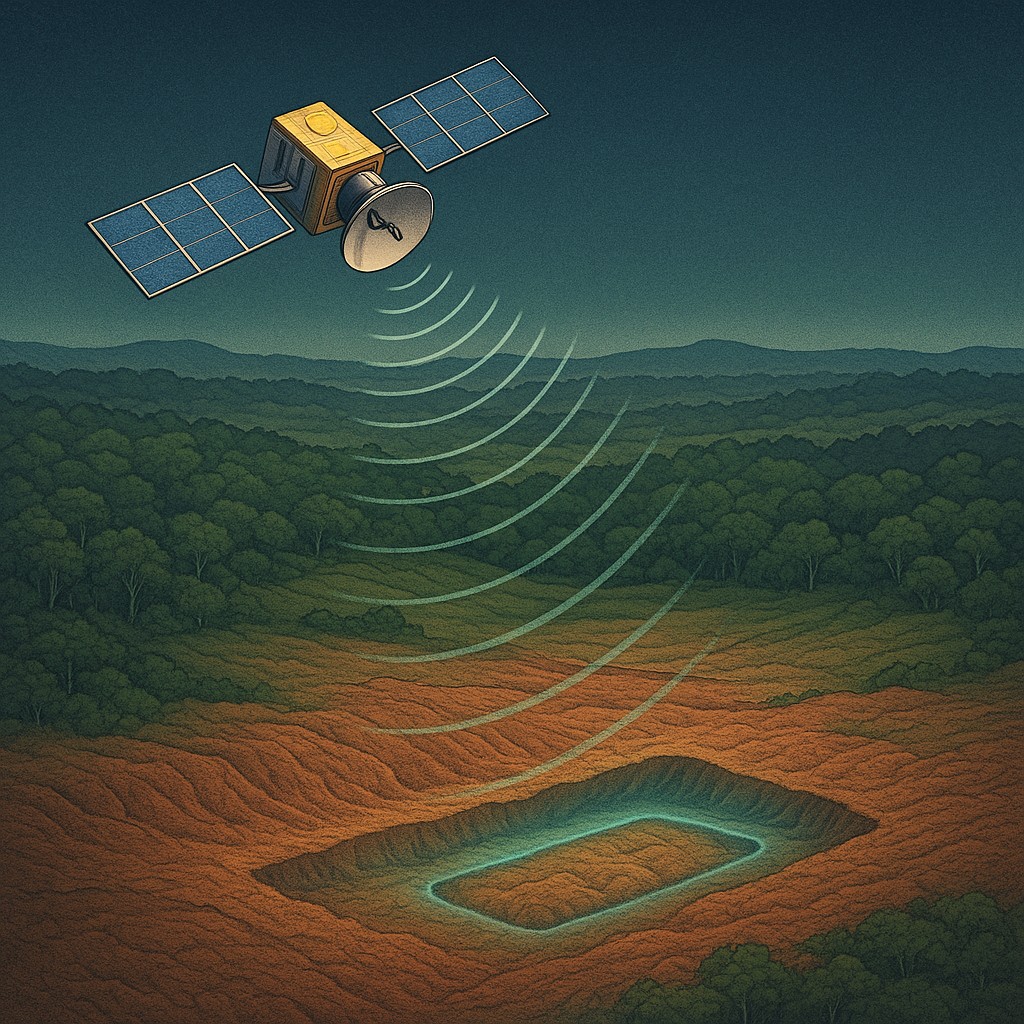
But the earth has a much longer memory than we realize, and it speaks in a language of tiny shifts that the human eye cannot see. Every time we move soil, we change its physical structure. This creates a "signature" of the disturbance that lasts long after the grass grows back or tire tracks fade. To read this hidden history, investigators are now turning to a sophisticated form of orbital "touch." They use radar systems that don't just take pictures of what the world looks like, but measure exactly how it sits. By bouncing microwave pulses off the ground from hundreds of miles up, international courts are finding they can detect the subtle sinking of earth that points to a hidden burial site. The very crust of the planet is becoming a witness for the prosecution.
The Microwave Whisperer in Orbit
The technology making this possible is known as Synthetic Aperture Radar, or SAR. Unlike the cameras on your smartphone or the high-powered telescopes on standard spy satellites, SAR does not need sunlight to see. Instead, it acts like a giant, ultra-precise bat. The satellite sends out its own pulses of microwave radiation. these waves travel through clouds, smoke, and even thick leaves to strike the ground and bounce back. Because the satellite knows exactly when it sent the signal and when it received it, it can calculate the distance to the surface with incredible accuracy. By combining multiple passes over the same area - a process called Interferometric SAR (InSAR) - scientists can detect changes in the ground's height smaller than the thickness of a penny.
The "synthetic aperture" part of the name refers to a clever bit of math and physics. A physical radar antenna would need to be miles long to get this kind of detail from space. To bypass this, the satellite uses its own forward motion. As it flies over a target, it takes thousands of snapshots from different positions along its flight path. A computer then stitches these signals together as if they came from one massive, virtual antenna. The result is a high-resolution map of the earth's shape that responds to physical texture and elevation rather than colors or light. For an investigator, the environment is no longer a hiding place, but a set of data.
Reading the Subsidence Signal
When a large amount of earth is dug up and then filled back in, it never returns to its original, packed state immediately. This is a basic rule of forensic soil science. Natural ground has spent centuries, even thousands of years, settling under the weight of gravity and the flow of water. When people dig a deep trench, the soil becomes airy and "fluffed." Even if the perpetrators pack the dirt back down and try to level the surface, the internal structure of the ground is ruined. Over the following months and years, as moisture seeps in and air pockets collapse, the ground begins to sink. This is a process known as subsidence.
This sinking is not random. Natural erosion usually follows the curves of the land, washing away topsoil in predictable sheets or carving out gullies where water drains. In contrast, a man-made disturbance like a mass grave creates a distinct "trough" or dip that matches the shape of the original hole. SAR satellites can track these subtle depressions over a "temporal stack," which is simply a series of images taken over several months. If a patch of ground in a remote valley sinks by five millimeters every month while the surrounding hills stay still, it tells investigators that something significant happened beneath the dirt. This allows them to build a timeline, linking physical changes in the landscape to specific dates when troop movements or violence were reported.
Separating Crimes from the Chaos of Nature
The earth is a busy place, and it moves constantly for reasons that have nothing to do with human conflict. If forensic SAR were as simple as looking for sinking ground, every swamp, sand dune, and construction site would look like a crime scene. To be useful in court, the data must be filtered through a strict process of "clutter rejection" to ensure that natural events aren't mistaken for evidence of atrocities. This is where geophysicists and legal investigators work together to rule out false leads.
| Type of Feature |
How the Elevation Changes |
Context of the Findings |
| Undisturbed Soil |
Little to no change over time. |
A stable baseline showing no recent deep digging. |
| Natural Wetlands |
Seasonal "breathing" (rising and falling). |
Matches local rainfall and seasonal flooding. |
| Shifting Sand Dunes |
Side-to-side and up-and-down movement. |
Follows wind patterns and lacks a fixed "trough" shape. |
| Fresh Excavation |
Initial slight bulge followed by steady sinking. |
Clear geometric patterns that don't match local geology. |
| Construction Sites |
Rapid rise in height followed by stability. |
Usually marked by new buildings or road access. |
By comparing SAR data against the geological history of the region, analysts can find anomalies that "break the rules" of that specific environment. In a dry, rocky highland, any significant sinking is highly suspicious. In a river delta where mud is always moving, the bar for evidence is much higher. This skepticism is vital because the goal is not just to find a site, but to provide "probative value" - meaning evidence strong enough to prove a point in a legal case. A defense lawyer will quickly blame a rainy season or a small earthquake for ground shifts; SAR allows prosecutors to show that the specific shape and speed of the sinking are mathematically impossible for those natural events.
The Strategic Advantage of Invisible Eyes
One of the most painful parts of human rights work is the "observer effect." When investigators show up in a conflict zone with shovels and ground radar, they often alert the very people they are investigating. This can lead to witness intimidation, the destruction of evidence, or even direct danger to the teams. SAR allows for "clandestine" or secret investigations from the safety of space. People on the ground have no way of knowing when they are being "touched" by a satellite pulse, so they cannot try to hide the sinking or move the evidence before the investigation begins.
This remote capability also solves the problem of distance. In the past, finding a hidden burial site in a country the size of Sudan or Ukraine was a matter of luck and tips. With SAR, agencies can scan entire provinces at once. Instead of sending a team to wander through a thousand square miles of forest, the satellite can point to three specific 50-meter spots that show suspicious sinking. This drastically cuts the cost and risk of field missions. It ensures that when investigators finally arrive, they have a digital map telling them exactly where to dig, turning a blind search into a targeted recovery.
Navigating the Limits of the Land
While SAR is a groundbreaking tool, it is not a magic wand. Microwaves are great at seeing through things, but they are still bound by physics. In very sandy deserts, for example, the wind moves the surface so often that the "noise" of shifting dunes can drown out the tiny signal of soil sinking deep below. Similarly, in high mountains, steep slopes can cause "radar shadows" or distortions that make it hard for the signal to bounce back clearly. in these places, SAR acts more like a supporting witness than the star of the show, requiring teams on the ground to confirm what the satellite suspects.
There is also the question of what happens after a site is found. Radar can tell you the ground was disturbed, but it cannot tell you who is there or how they died. It provides the "where" and the "when," but the "who" and the "how" still require the patient, difficult work of forensic experts and DNA analysts. The technology serves as a bridge between the vast, unmonitored parts of the world and the strict requirements of a courtroom. It makes it much harder for criminals to get away with their actions by proving that even if a crime happens in total darkness, the earth is keeping a tally.
The Future of Global Accountability
Using SAR in international law marks a shift in how we think about secrets and national borders. We are entering an era where the physical state of segments of the planet is recorded so often and so precisely that "disappearing" something becomes impossible. As satellite networks grow and the math for processing ground movement improves, the time between a crime and its detection will shrink from years to days. This is about more than just catching people; it is about creating a "digital twin" of the earth's surface that warns anyone who thinks they can act without leaving a record.
For students of law and science, this mix of physics and justice is a reminder that technology is about more than just "cool gadgets." It is about expanding what we can prove and who we can protect. When we look at a satellite image of a sinking patch of dirt in a remote forest, we aren't just looking at data; we are seeing the beginning of a conversation between the victims of the past and the judges of the future. The earth may be silent, but through the lens of modern science, it has become one of our most reliable storytellers. Even in the most hidden corners of the globe, the truth has a way of rising to the surface, one millimeter at a time.