Imagine you are standing on a beach, scrolling through social media or watching a video of a kitten playing a piano. It feels like the data is floating through the air, perhaps beamed down from a satellite or bouncing off a nearby cell tower. In reality, that data is likely racing through a strand of glass no thicker than a human hair, buried thousands of feet below the ocean surface. Roughly 95 to 99 percent of all international data travels via submarine fiber-optic cables. These cables are the true nervous system of our modern world; they carry trillions of dollars in financial transactions and the sum of human knowledge across the dark, silent depths of the seafloor.
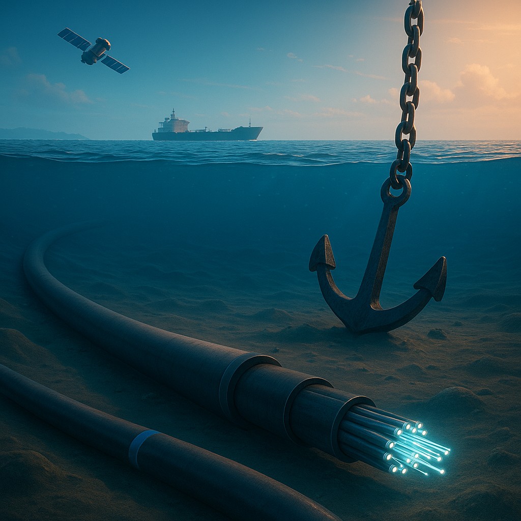
Despite their vital importance, these cables are surprisingly fragile. They are not indestructible titanium pipes, but are often just reinforced lines about the size of a garden hose resting on the sand. While we often worry about high-tech spies or deep-sea monsters, the most common threat to the global internet is actually a very old human invention: the anchor. When a fishing trawler drags its gear or a massive cargo ship drops its anchor in the wrong spot, it can trigger a digital blackout for an entire region. To combat this, a new wave of international maritime security projects is redrawing ocean maps. These initiatives introduce "buffer zones" that treat undersea cables less like hidden trash and more like high-voltage power lines that must not be touched.
The Invisible Web Beneath the Waves
To understand why these new buffer zones matter, we first need to look at what we are protecting. A submarine cable is a feat of engineering that resembles a giant layered cake. At the very center are the optical fibers, which carry data using pulses of light. Surrounding these fibers are layers of petroleum jelly for waterproofing, copper to provide electricity to repeaters (devices that boost the signal), and several layers of steel wire and plastic for strength. Near the shore, where the water is shallow and risks are higher, cables are "armored" with extra metal. However, in the deep ocean, they are often surprisingly thin because the environment there is generally very still.
The problem arises when the deep ocean isn't as quiet as we thought. Human activity in the "blue economy" has exploded over the last few decades. We are not just fishing and shipping anymore; we are building wind farms, mining the seabed, and navigating massive vessels with anchors weighing several tons. When an anchor drags across the seabed, it acts like a giant plow. If it hits a cable, it doesn't just scratch it; it snags, stretches, and eventually snaps it. This isn't just a theory. Data from the International Cable Protection Committee (ICPC) suggests that human activity, specifically fishing and anchoring, accounts for over two-thirds of all cable faults worldwide.
Shifting from Reactive Repairs to Proactive Prevention
Historically, the law of the sea was a bit like the Wild West for cables. If a cable was cut, the owner would send out a specialized repair ship, which could take weeks to arrive and millions of dollars to operate. The legal focus was on who should pay for the damage after the internet had already gone down. However, in a world where a three-day internet outage can cause a national economic crisis, waiting for things to break is no longer a viable strategy. Modern maritime initiatives are shifting the focus toward spatial management, which is a practical way of deciding who is allowed to be where before anyone gets hurt.
These new buffer zones, or "Submarine Cable Protection Zones," are officially designated areas of the ocean where specific activities are strictly regulated or banned. In these zones, you might be allowed to sail your boat, but you cannot drop an anchor or use "bottom-trawling" fishing nets that scrape the floor. By creating a physical gap between the cable and heavy machinery, authorities create a margin for error. If a ship's engine fails and it starts to drift, the buffer zone provides enough distance for the Coast Guard to step in before the ship is forced to drop an anchor directly onto the backbone of the regional internet.
High-Tech Eyes Watching the Sea
You might wonder how a country can possibly enforce a no-anchoring rule in the middle of a vast, foggy ocean. The answer lies in a combination of satellite surveillance and the Automatic Identification System (AIS). Almost every large commercial vessel must carry an AIS transponder, which broadcasts its location, speed, and heading in real time. This is essentially a GPS social network for ships. Authorities can now set up "geofenced" alerts, which act like virtual fences. The moment a ship enters a protected cable zone and slows down to a speed that suggests it might be fishing or anchoring, an automated alert is sent to a maritime operations center.
This digital monitoring is supplemented by synthetic aperture radar (SAR) satellites. These can see through clouds and darkness to spot "dark vessels," or ships that have turned off their AIS transponders. By layering these technologies, security agencies can create a map that stays updated every few minutes. If a vessel is spotted loitering in a buffer zone off the coast of Australia or in the busy waters of the English Channel, patrol boats can be dispatched immediately to warn them away. This shift from "fixing" to "monitoring" represents a massive leap in how we think about international infrastructure.
Comparing Old Limits and New Protections
To see how these initiatives change the landscape, it helps to look at how maritime space was managed in the past compared to how these new protective zones operate today.
| Feature |
Traditional Maritime Law |
Modern Cable Buffer Zones |
| Primary Goal |
Freedom of navigation |
Infrastructure resilience |
| Enforcement |
Reactive (fines after damage) |
Proactive (monitoring and warnings) |
| Technology |
Visual sightings and logs |
AIS, Satellites, and Geofencing |
| Vessel Restrictions |
Mostly unrestricted passage |
Restricted anchoring and trawling |
| Legal Basis |
UNCLOS general provisions |
Specific national or regional laws |
| Economic Focus |
Protecting shipping rights |
Protecting the digital economy |
Navigating the Legal and Political Waters
Creating these zones isn't always as simple as drawing a line on a map. The ocean is divided into different legal neighborhoods based on the United Nations Convention on the Law of the Sea (UNCLOS). Near the coast, in "Territorial Waters," a country has a lot of power to make its own rules. Further out, in the "Exclusive Economic Zone" (EEZ), things get trickier because other nations have the right to navigate freely. Implementing a buffer zone in international waters requires careful diplomacy. Countries must convince their neighbors and the international shipping community that these restrictions are for the greater good of global connectivity.
There is also the challenge of accidental versus intentional damage. While these buffer zones are excellent at stopping a confused fishing boat or a drifting freighter, they aren't necessarily a fortress against a professional group or a military force intent on sabotage. If someone wants to cut a cable on purpose, a line on a map won't stop them. However, what these zones do provide is a way to clear out the "noise." In a well-monitored buffer zone, any ship that shouldn't be there stands out instantly. By removing hundreds of fishing boats from the area, security forces can more easily identify suspicious behavior that might signal a deliberate attack.
The Future of the Ocean Floor
As we look toward the future, the ocean floor is only going to get more crowded. We are seeing the rise of "smart cables" that not only carry data but also have sensors to monitor climate change and tectonic activity to provide early tsunami warnings. We are also developing undersea power grids to connect offshore wind farms to the mainland. All of this infrastructure will require the same buffer zone logic that we currently apply to internet cables. We are essentially building a city on the seafloor, and every city needs its "no-dig" zones and zoning laws to keep the lights on and the data flowing.
The move toward these maritime security initiatives shows a growing maturity in how we view the internet. We are finally moving past the myth that "the cloud" is an ethereal, untouchable entity in the sky. By treating the seafloor as a managed space, we are acknowledging that our digital lives are tethered to the physical world. These buffer zones are more than just legal boundaries; they are a commitment to protecting our shared human communication. They serve as a reminder that even in an age of artificial intelligence, our most advanced systems still rely on the simple, physical act of keeping a heavy piece of metal from hitting a glass straw at the bottom of the sea.
As you finish reading, take a moment to look at your phone or computer. Imagine the invisible thread stretching from your device, across the land, and diving into the cold, dark Atlantic or Pacific. Somewhere out there, a ship is being told to move along, and a satellite is pinging a warning, all so that you can stay connected. The ocean is no longer just a place for adventure; it is the silent, protected guardian of the digital age. By learning about these initiatives, you have seen the invisible guardrails that keep our global civilization running, proving once again that the most important parts of our world are often the ones we cannot see.